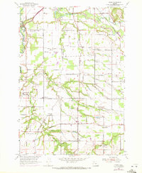
1955 Map of Yoder
USGS Topo · Published 1972About this map
Elliott Prairie and Gribble Prairie anchor this agricultural region between the Molalla River and Pudding River, where early Oregon settlement patterns are visible through numerous small communities and family-named landmarks. The landscape is defined by the convergence of several waterways, including Milk Creek, Bear Creek, and Rock Creek, which carved the drainages that dictated local road placement. In the mid-1950s, the rural character is emphasized by the cluster of local institutions like Smyrna Ch, Rock Creek Ch, and Ninety-one Sch. The infrastructure of the Southern Pacific railroad and the Pacific Highway near Barlow and Canby contrasts with the network of unimproved dirt roads and an Old Grade further south near Yoder. Researchers will find a high concentration of burial grounds, including the Norwegian Cem and Whiskey Hill Cem, reflecting the diverse cultural heritage of the Marion and Clackamas county borderlands.
Find a feature on this map
40 named features on this map. Tap any name to fly to it.
Don’t see what you’re looking for? This feature index may not catch every label — zoom into the map to look around manually.
Map Details
Editions of this 1955 Yoder Map
3 editions found
Other maps of this area

1914 · Oregon City
USGS Topo · 1:62,500

1916 · Tualatin
USGS Topo · 1:62,500

1923 · Mount Angel
USGS Topo · 1:62,500

1939 · Molalla
USGS Topo · 1:62,500

1939 · Oregon City
USGS Topo · 1:62,500

1939 · Tualatin
USGS Topo · 1:62,500

1940 · Tualatin
USGS Topo · 1:62,500

1940 · Molalla
USGS Topo · 1:62,500

1940 · Mount Angel
USGS Topo · 1:62,500

1941 · Oregon City
USGS Topo · 1:62,500