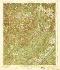
1935 Map of Yolande
USGS Topo · Published 1935About this map
The industrial and rural landscapes of southwest Jefferson County are defined by the convergence of the Louisville and Nashville and Southern Railway lines as they cut through the ridges of Rock Mountain. This mid-1930s survey captures the region during a period of heavy mineral extraction, evidenced by the Gilmore Mines and numerous company-associated settlements like Yolande, Rockcastle, and Connellsville. The terrain is characterized by the winding Warrior River at Sextons Bend and the sharp parallel ridges of Red Mountain and Shades Mountain to the east.
Find a feature on this map
84 named features on this map. Tap any name to fly to it.
Don’t see what you’re looking for? This feature index may not catch every label — zoom into the map to look around manually.
Map Details
Editions of this 1935 Yolande Map
3 editions found

Other maps of this area

1889 · Birmingham
USGS Topo · 1:125,000

1890 · Bessemer
USGS Topo · 1:125,000

1892 · Birmingham
USGS Topo · 1:125,000

1892 · Bessemer
USGS Topo · 1:125,000

1893 · Jasper
USGS Topo · 1:125,000

1895 · Birmingham
USGS Topo · 1:125,000

1899 · Brookwood
USGS Topo · 1:125,000

1904 · Birmingham Coal District
USGS Topo · 1:62,500

1905 · Bessemer Iron District
USGS Topo · 1:62,500

1906 · Birmingham Special
USGS Topo · 1:62,500