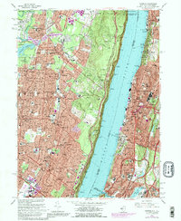
1966 Map of Yonkers
USGS Topo · Published 1980About this map
The Palisades rise sharply above the Hudson River, forming a natural barrier between the expanding suburban communities of New Jersey and the industrial and residential corridors of New York. In the mid-1960s, this landscape was characterized by a dense network of towns like Englewood, Dumont, and Bergenfield, which are shown here during a period of significant post-war growth. On the eastern shore, the city of Yonkers and the northern reaches of the Bronx show a complex urban fabric where major transit arteries like the Henry Hudson Pkwy and the Major Deegan Expwy intersect with long-standing landmarks. Large-scale institutional and recreational land use is evident in the sprawling Van Cortlandt Park, the historic Woodlawn Cemetery, and the Jerome Park Reservoir. This era captures the transition of the riverfront from its industrial roots toward more recreational uses, visible at locations like the Palisade Boat Club and Alpine Boat Basin.
Find a feature on this map
98 named features on this map. Tap any name to fly to it.
Don’t see what you’re looking for? This feature index may not catch every label — zoom into the map to look around manually.
Map Details
Editions of this 1966 Yonkers Map
3 editions found
Other maps of this area

1888 · Paterson
USGS Topo · 1:62,500

1891 · Ramapo
USGS Topo · 1:62,500

1891 · Harlem
USGS Topo · 1:62,500

1892 · Paterson
USGS Topo · 1:62,500

1892 · Tarrytown
USGS Topo · 1:62,500

1893 · Tarrytown
USGS Topo · 1:62,500

1893 · Ramapo
USGS Topo · 1:62,500

1897 · Harlem
USGS Topo · 1:62,500

1898 · Harlem
USGS Topo · 1:62,500

1898 · Paterson
USGS Topo · 1:62,500