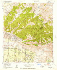
1949 Map of Yorba Linda
USGS Topo · Published 1957About this map
Olinda Oil Field dominates the western landscape of this mid-century survey, where dense clusters of Oil Wells reveal the industrial foundation of the region. The transition from extraction to agriculture is evident around Yorba Linda, where gridded groves and citrus lands meet the northern hills. Transportation networks like the Pacific Electric railroad and the Pacific Highway connect the emerging settlements of Placentia and Esperanza to the wider Southern California basin.
Find a feature on this map
34 named features on this map. Tap any name to fly to it.
Don’t see what you’re looking for? This feature index may not catch every label — zoom into the map to look around manually.
Map Details
Editions of this 1949 Yorba Linda Map
2 editions found
Other maps of this area

1894 · Pomona
USGS Topo · 1:62,500

1896 · Anaheim
USGS Topo · 1:62,500

1897 · Pomona
USGS Topo · 1:62,500

1897 · Cucamonga
USGS Topo · 1:62,500

1898 · Pomona
USGS Topo · 1:62,500

1898 · Anaheim
USGS Topo · 1:62,500

1900 · Cucamonga
USGS Topo · 1:62,500

1901 · Southern California Sheet No. 1
USGS Topo · 1:250,000

1901 · Anaheim
USGS Topo · 1:62,500

1902 · Corona
USGS Topo · 1:125,000