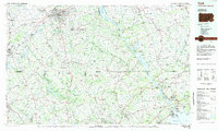
1983 Map of York
USGS Topo · Published 1984About this map
The Susquehanna River carves a massive path through this South Central Pennsylvania landscape, serving as a natural boundary between York and Lancaster counties while feeding the Conowingo Reservoir and Lake Clarke. The city of York sits as a central hub for transport, surrounded by a dense network of suburban and rural boroughs including Dallastown, Red Lion, and Spry. Industrial and transit corridors are well-established by the early 1980s, with Conrail and Amtrak lines tracing the river valleys and connecting these manufacturing centers to the Chesapeake Bay via the Aberdeen Proving Grounds. To the west, the landscape rises into the Pigeon Hills and Rocky Ridge, while the southern reaches extend across the Mason-Dixon line into Maryland, where the Prettyboy Reservoir and Gunpowder Falls dominate the northern Baltimore County terrain. This planimetric study documents the mid-century suburban expansion and the preserved state game lands that punctuate the hillsides between the river and the Maryland border.
Find a feature on this map
188 named features on this map. Tap any name to fly to it.
Don’t see what you’re looking for? This feature index may not catch every label — zoom into the map to look around manually.
Map Details
Editions of this 1983 York Map
2 editions found
Other maps of this area

1892 · Ellicott
USGS Topo · 1:62,500

1893 · Gunpowder
USGS Topo · 1:62,500

1893 · Frederick
USGS Topo · 1:125,000

1894 · Ellicott
USGS Topo · 1:62,500

1894 · Baltimore
USGS Topo · 1:62,500

1894 · Frederick
USGS Topo · 1:125,000

1898 · Elkton
USGS Topo · 1:62,500

1898 · Tolchester
USGS Topo · 1:125,000

1899 · Dover
USGS Topo · 1:125,000

1899 · Baltimore
USGS Topo · 1:62,500