
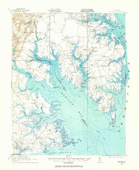
1943 Map of Yorktown
USGS Topo · Published 1943About this map
Yorktown and the surrounding Tidewater region appear here in a compilation reflecting the military geography of the early 1940s. The landscape is defined by the massive confluence of the James River and the Warwick River, where maritime activity is noted by a steamboat route and several light houses including White Shoal LH. This sheet provides a detailed view of a peninsula steeped in colonial and Civil War history, showing the National Cem and Old Fort Yorktown alongside defensive positions like Old Fort McPherson and Old Earthworks. The inland areas are dotted with small post offices and rural crossroads such as Denbigh PO and Bacons Castle, while the Chesapeake and Ohio RR cuts through the northern timberlands near the Oriana Lumber Co. Significant ruins at Fort Crawford and Fort Boykin underscore the strategic importance of this riverfront throughout various eras of American conflict.
Find a feature on this map
76 named features on this map. Tap any name to fly to it.
Don’t see what you’re looking for? This feature index may not catch every label — zoom into the map to look around manually.
Map Details
Editions of this 1943 Yorktown Map
This is the sole edition of this map. No revisions or reprints were ever made.
Other maps of this area

1906 · Williamsburg
USGS Topo · 1:62,500

1907 · Norfolk
USGS Topo · 1:125,000

1907 · Yorktown
USGS Topo · 1:62,500

1907 · Hampton
USGS Topo · 1:62,500
1916 · Mathews
USGS Topo · 1:62,500
1917 · Mathews
USGS Topo · 1:62,500

1917 · Toano
USGS Topo · 1:62,500

1918 · Toano
USGS Topo · 1:62,500

1919 · Smithfield
USGS Topo · 1:62,500

1919 · Surry
USGS Topo · 1:62,500