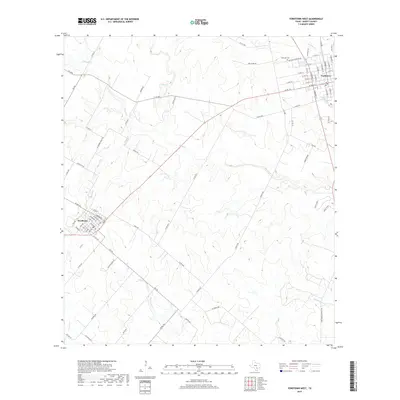
2019 Map of Yorktown West
USGS Topo · Published 2019About this map
Yorktown and Nordheim anchor this DeWitt County landscape, connected by a network of ranch-to-market roads and rural routes that cross the numerous watercourses of the Guadalupe River basin. The terrain is defined by a dense web of seasonal and perennial drainage, including the headwaters of Manahuilla Cr and Eighteenmile Cr. Settlement patterns follow the higher ground between these creeks, with long-established family landholdings indicated by local names like Roeder Rd, Schneider Ranch Rd, and Willie Buesing Rd. In Yorktown, the street grid extends toward the Westside Cem, while Nordheim shows a compact residential layout north of FM 239. The map documents a predominantly agricultural and ranching economy, where the placement of cattle guards and private lanes provides insight into the modern management of historic Texas land grants.
Find a feature on this map
90 named features on this map. Tap any name to fly to it.
Don’t see what you’re looking for? This feature index may not catch every label — zoom into the map to look around manually.
Map Details
Editions of this 2019 Yorktown West Map
This is the sole edition of this map. No revisions or reprints were ever made.
Other maps of this area

1920 · Smiley
USGS Topo · 1:125,000

1953 · Beeville
USGS Topo · 1:250,000

1953 · Seguin
USGS Topo · 1:250,000

1956 · Beeville
USGS Topo · 1:250,000

1958 · Seguin
USGS Topo · 1:250,000

1960 · Beeville
USGS Topo · 1:250,000

1960 · Blackwell Lake
USGS Topo · 1:24,000

1961 · New Davy
USGS Topo · 1:24,000
1963 · Choate
USGS Topo · 1:24,000

1963 · Weesatche
USGS Topo · 1:24,000