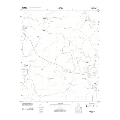
2011 Map of Yorkville
USGS Topo · Published 2011About this map
The Yorkville Mine and Baxter Prospect anchor the southern landscape of this Paulding County survey, reflecting a history of local resource extraction. The area is defined by the winding course of Raccoon Creek and Pumpkinvine Creek, which are segmented by numerous small reservoirs such as Willow Springs Lake and Womack Lake. In the northern section, the settlement of Braswell sits near the crossing of the Silver Comet Trl, a prominent feature that cuts diagonally across the terrain. Genealogists will find several burial grounds of interest, including the Old High Shoals Cemetery and Friendship Cemetery. Historical infrastructure is represented by the Archibald Holland Bridge over Raccoon Creek, while small communities like Beatty Switch and Divide mark former rail stops or crossroads. The map also captures the topography of Brushy Mountain and Scoggins Ridge, providing a clear look at the region’s drainage patterns and rural road network during the early 21st century.
Find a feature on this map
85 named features on this map. Tap any name to fly to it.
Don’t see what you’re looking for? This feature index may not catch every label — zoom into the map to look around manually.
Map Details
Editions of this 2011 Yorkville Map
This is the sole edition of this map. No revisions or reprints were ever made.
Other maps of this area

1886 · Rome
USGS Topo · 1:125,000

1889 · Tallapoosa
USGS Topo · 1:125,000

1890 · Cartersville
USGS Topo · 1:125,000

1891 · Marietta
USGS Topo · 1:125,000

1891 · Cartersville
USGS Topo · 1:125,000

1892 · Tallapoosa
USGS Topo · 1:125,000

1895 · Marietta
USGS Topo · 1:125,000

1896 · Cartersville
USGS Topo · 1:125,000

1897 · Marietta
USGS Topo · 1:125,000

1897 · Tallapoosa
USGS Topo · 1:125,000