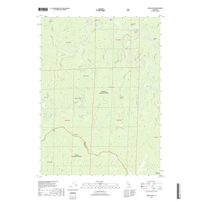
2018 Map of Youngs Peak
USGS Topo · Published 2018About this map
Youngs Peak stands as a prominent high point along the boundary between Klamath National Forest and Trinity National Forest, where the county line separates Siskiyou and Trinity counties. This mountain landscape is defined by the headwaters of numerous drainages, including Knownothing Cr and its eastern and western forks, which feed toward the South Fork Salmon River in the northeast. The map reveals a network of ridges and gulches often named for early mining or ranching figures, such as Hotelling Ridge and O'Farrill Gulch. Near the river, the presence of Missouri Bar and Shingle Flat suggests areas of historic riverfront activity. High-altitude features like Knownothing Lake and Slate Gap illustrate the drainage patterns of the Salmon Mountains, providing a detailed view of this wilderness area's topography before it descends into deep canyons like Poverty Gulch.
Find a feature on this map
51 named features on this map. Tap any name to fly to it.
Don’t see what you’re looking for? This feature index may not catch every label — zoom into the map to look around manually.
Map Details
Editions of this 2018 Youngs Peak Map
This is the sole edition of this map. No revisions or reprints were ever made.
Other maps of this area

1948 · Weed
USGS Topo · 1:250,000

1950 · Weed
USGS Topo · 1:250,000

1955 · Salmon Mtn
USGS Topo · 1:62,500

1955 · Cecilville
USGS Topo · 1:62,500

1955 · Sawyers Bar
USGS Topo · 1:62,500

1955 · Forks of Salmon
USGS Topo · 1:62,500

1958 · Weed
USGS Topo · 1:250,000

1963 · Weed
USGS Topo · 1:250,000

1974 · Orleans Mtn.
USGS Topo · 1:24,000
1978 · Cecilville
USGS Topo · 1:24,000