
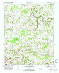
1952 Map of Youngville
USGS Topo · Published 1953About this map
The Swamps and the winding course of the South Fork Red River dominate the northern landscape of this Robertson County survey. The 1950s rural economy is clearly visible through a network of small agricultural settlements like Ashburn, Youngville, and Milldale, while a more industrial footprint appears near the State Fish Hatchery and its accompanying dam. In the southwest corner, the growing edge of Springfield is represented by a Substation and a cluster of residences near Wartrace Lake. Local social life is mapped through numerous family-named and community landmarks, from Brick Sch in the north to Owens Chapel and Beards Chapel in the south. The transition from timber and wetlands to managed farmland is illustrated by the clearings around Beaver Creek and Sulphur Fork Creek, providing a detailed view of Tennessee's mid-century landscape.
Find a feature on this map
33 named features on this map. Tap any name to fly to it.
Don’t see what you’re looking for? This feature index may not catch every label — zoom into the map to look around manually.
Map Details
Editions of this 1952 Youngville Map
2 editions found
Other maps of this area

1903 · Nashville
USGS Topo · 1:125,000

1931 · Ridgetop
USGS Topo · 1:62,500

1935 · Ridgetop
USGS Topo · 1:62,500

1942 · Gallatin
USGS Topo · 1:100,000

1951 · Adairville
USGS Topo · 1:24,000

1951 · Dot
USGS Topo · 1:24,000

1951 · Prices Mill
USGS Topo · 1:24,000

1952 · Springfield North
USGS Topo · 1:24,000

1953 · Orlinda
USGS Topo · 1:24,000
1954 · White House
USGS Topo · 1:24,000