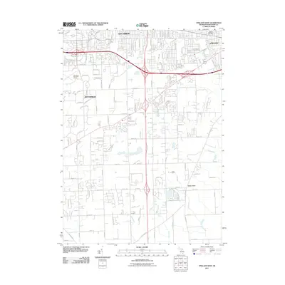
2011 Map of Ypsilanti West
USGS Topo · Published 2011About this map
Ann Arbor and Ypsilanti anchor the northern reaches of this landscape, where the urban expansion of Washtenaw County meets the agricultural and drainage networks of Pittsfield. The northern edge is dominated by institutions and infrastructure, including the campus of Eastern Michigan University and the Ann Arbor Municipal Airport, while the terrain to the south transitions into a complex system of managed waterways like Hewens Drain and Koch Warner Drain. These man-made and natural channels illustrate the region's efforts to manage the wetlands and low-lying areas of the Huron River watershed.
Find a feature on this map
124 named features on this map. Tap any name to fly to it.
Don’t see what you’re looking for? This feature index may not catch every label — zoom into the map to look around manually.
Map Details
Editions of this 2011 Ypsilanti West Map
This is the sole edition of this map. No revisions or reprints were ever made.
Other maps of this area

1902 · South Lyon
USGS Topo · 1:62,500

1902 · Ypsilanti
USGS Topo · 1:62,500

1902 · Dexter
USGS Topo · 1:62,500

1904 · Ann Arbor
USGS Topo · 1:125,000

1906 · Ypsilanti
USGS Topo · 1:62,500

1906 · Dexter
USGS Topo · 1:62,500

1906 · Saline
USGS Topo · 1:62,500

1906 · South Lyon
USGS Topo · 1:62,500

1908 · Ann Arbor
USGS Topo · 1:125,000
1936 · Denton
USGS Topo · 1:31,680
Featured Places
- Ann Arbor, MI
- Ypsilanti Charter Township, MI
- Pittsfield Charter Township, MI
- Ypsilanti, MI
- York Charter Township, MI