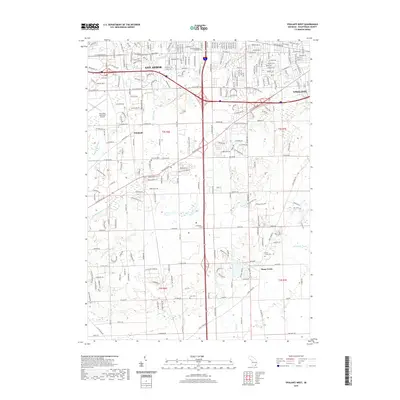
2019 Map of Ypsilanti West
USGS Topo · Published 2019About this map
The Historic Terhune Graveyard and Stony Creek Cem serve as quiet markers of the long-standing communities between Ann Arbor and Ypsilanti. This 2019 survey captures the developed suburban corridors along W Michigan Ave and W Eisenhower Pkwy while documenting the agricultural roots of the southern townships. The landscape is heavily defined by its managed water systems, including the Chalmers Drain, Swift Drain, and Pittsfield Number Five Drain, reflecting the transformation of former marshlands into productive farmland and residential neighborhoods. Key local landmarks like the Ann Arbor Municipal Airport and the recreational grounds of Rolling Hills Park illustrate the modern utility of the Pittsfield and Stony Creek areas as they bridge the gap between two of Michigan's major university towns.
Find a feature on this map
45 named features on this map. Tap any name to fly to it.
Don’t see what you’re looking for? This feature index may not catch every label — zoom into the map to look around manually.
Map Details
Editions of this 2019 Ypsilanti West Map
This is the sole edition of this map. No revisions or reprints were ever made.
Other maps of this area

1902 · South Lyon
USGS Topo · 1:62,500

1902 · Ypsilanti
USGS Topo · 1:62,500

1902 · Dexter
USGS Topo · 1:62,500

1904 · Ann Arbor
USGS Topo · 1:125,000

1906 · Ypsilanti
USGS Topo · 1:62,500

1906 · Dexter
USGS Topo · 1:62,500

1906 · Saline
USGS Topo · 1:62,500

1906 · South Lyon
USGS Topo · 1:62,500

1908 · Ann Arbor
USGS Topo · 1:125,000
1936 · Denton
USGS Topo · 1:31,680
Featured Places
- Ann Arbor, MI
- Ypsilanti Charter Township, MI
- Pittsfield Charter Township, MI
- Ypsilanti, MI
- York Charter Township, MI