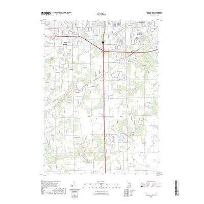
2023 Map of Ypsilanti West
USGS Topo · Published 2023About this map
Ann Arbor and Ypsilanti serve as the urban anchors for this southern Michigan landscape, where residential expansion meets established agricultural and transit corridors. The area is defined by a complex network of managed waterways, including the Pittsfield Number Five Drain, Koch Warner Drain, and McCarthy Drain, illustrating the region's long-term reliance on drainage infrastructure for both farming and development. The presence of several family and community burial grounds, such as Pioneer Cem and Crittenden Cem, provides a genealogical footprint of the early settlers who established the townships of Pittsfield and Stony Creek. The western portion is dominated by the Ann Arbor Municipal Airport, while the southern reaches follow the meandering paths of Sugar Creek and Buck Creek. This modern survey documents the contemporary interface between the suburban outskirts of two major university towns and the rural character of the surrounding Washtenaw County townships.
Find a feature on this map
90 named features on this map. Tap any name to fly to it.
Don’t see what you’re looking for? This feature index may not catch every label — zoom into the map to look around manually.
Map Details
Editions of this 2023 Ypsilanti West Map
This is the sole edition of this map. No revisions or reprints were ever made.
Other maps of this area

1902 · South Lyon
USGS Topo · 1:62,500

1902 · Ypsilanti
USGS Topo · 1:62,500

1902 · Dexter
USGS Topo · 1:62,500

1904 · Ann Arbor
USGS Topo · 1:125,000

1906 · Ypsilanti
USGS Topo · 1:62,500

1906 · Dexter
USGS Topo · 1:62,500

1906 · Saline
USGS Topo · 1:62,500

1906 · South Lyon
USGS Topo · 1:62,500

1908 · Ann Arbor
USGS Topo · 1:125,000
1936 · Denton
USGS Topo · 1:31,680
Featured Places
- Ann Arbor, MI
- Ypsilanti Charter Township, MI
- Pittsfield Charter Township, MI
- Ypsilanti, MI
- York Charter Township, MI