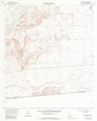
1957 Map of Yuha Basin
USGS Topo · Published 1985About this map
The Yuha Basin dominates this arid landscape, showing a complex network of dry washes and desert terrain as it appeared in the mid-20th century. The geological character of the region is defined by the prominent Yuha Buttes and the nearby Shell Beds, which indicate the marine history of this now-dry inland sink. The terrain transitions from the low-lying basin floor to the elevated West Mesa in the northeast, where the W Side Main Canal introduces irrigation infrastructure to the desert edge. This survey, based on 1940s planetable work and updated by 1950s aerial photography, captures the Yuha Desert before significant modern surface disturbances, preserving the original jeep trails and washes that served as the primary routes through the Imperial Valley's desert interior.
Find a feature on this map
6 named features on this map. Tap any name to fly to it.
Don’t see what you’re looking for? This feature index may not catch every label — zoom into the map to look around manually.
Map Details
Editions of this 1957 Yuha Basin Map
4 editions found
Other maps of this area

1915 · El Centro
USGS Topo · 1:125,000

1940 · Brawley
USGS Topo · 1:62,500

1940 · Heber
USGS Topo · 1:62,500

1940 · Plaster City
USGS Topo · 1:62,500

1940 · Coyote Wells
USGS Topo · 1:62,500

1942 · El Centro
USGS Topo · 1:250,000

1943 · Coyote Wells
USGS Topo · 1:62,500

1943 · Heber
USGS Topo · 1:62,500

1943 · Brawley
USGS Topo · 1:62,500

1944 · Plaster City
USGS Topo · 1:62,500