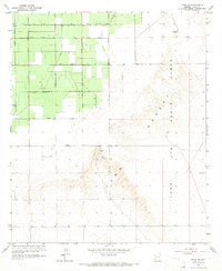
1965 Map of Yuma SE
USGS Topo · Published 1966About this map
Agricultural development meets military geography in this mid-1960s survey of the Arizona desert. The western portion of the map is defined by a grid of numbered roads, including 15th Street and 19th Street, supporting a system of irrigation via the Main Canal and A Canal. This structured landscape of wells and fields abruptly transitions to the eastern arid terrain of the Desert Range and the northern reaches of the Yuma landforms. A significant portion of the southeastern quadrant falls within the Luke Air Force Range, where the environment is characterized by open expanse and a few isolated landmarks like a Borrow Pit. A solitary Jeep Trail winds through the southwestern corner, suggesting the limited accessibility of the uncultivated desert areas during this era.
Find a feature on this map
14 named features on this map. Tap any name to fly to it.
Don’t see what you’re looking for? This feature index may not catch every label — zoom into the map to look around manually.
Map Details
Editions of this 1965 Yuma SE Map
3 editions found
Other maps of this area

1903 · Yuma
USGS Topo · 1:125,000

1905 · Yuma
USGS Topo · 1:125,000

1926 · Fortuna
USGS Topo · 1:62,500

1929 · Fortuna
USGS Topo · 1:62,500

1940 · Yuma
USGS Topo · 1:62,500

1942 · Yuma
USGS Topo · 1:250,000

1945 · Yuma
USGS Topo · 1:62,500

1952 · Yuma East
USGS Topo · 1:24,000

1952 · Yuma West
USGS Topo · 1:24,000

1954 · El Centro
USGS Topo · 1:250,000