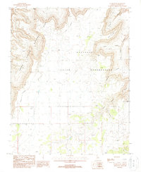
1988 Map of Yunosi Point
USGS Topo · Published 1988About this map
The Havasupai Indian Reservation dominates this 1980s landscape, meeting the boundary of Grand Canyon National Park along a high, broken plateau. The topography is defined by the dramatic descent into Beaver Canyon and Yunosi Point, where the terrain drops sharply from the level highlands into the canyon systems of the Colorado River drainage. The map records a sparsely developed wilderness where water management is critical, evidenced by the presence of Bishop Tank. Human impact is limited to the Trans Line and primitive tracks crossing the high ground near Tenderfoot and Dome. This survey captures the jurisdictional overlaps and natural landmarks of the Coconino plateau before modern digital mapping, including the Indefinite Boundary that runs through the rugged western section of the quadrangle.
Find a feature on this map
12 named features on this map. Tap any name to fly to it.
Don’t see what you’re looking for? This feature index may not catch every label — zoom into the map to look around manually.
Map Details
Editions of this 1988 Yunosi Point Map
This is the sole edition of this map. No revisions or reprints were ever made.
Other maps of this area

1886 · Kaibab
USGS Topo · 1:250,000

1953 · Grand Canyon
USGS Topo · 1:250,000

1957 · Grand Canyon
USGS Topo · 1:250,000

1958 · Grand Canyon
USGS Topo · 1:250,000

1960 · Grand Canyon
USGS Topo · 1:250,000

1962 · Kanab Point
USGS Topo · 1:62,500

1962 · Tuckup Canyon
USGS Topo · 1:62,500

1962 · Supai
USGS Topo · 1:62,500

1962 · National Canyon
USGS Topo · 1:62,500

1984 · Grand Canyon
USGS Topo · 1:100,000