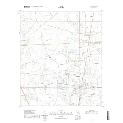
2020 Map of Zachary
USGS Topo · Published 2020About this map
Zachary and the surrounding East Baton Rouge Parish landscape are defined by a complex network of waterways, including Copper Mill Bayou, White Bayou, and Black Cr. This 2020 survey illustrates the developed residential corridors of the city, which transition into the more rural, open terrain of Plains and Lindsay to the west. The area is notable for its numerous small burial grounds that serve as vital links for family historians, such as Young Cem, Shaffer Cem, and the McHugh Cem located near the eastern edge of the quadrangle. Local aviation is represented by Slaughter Airpark near the town of Slaughter and Brian's Airport further south. The map provides a clear look at the parish line between East Feliciana Parish and East Baton Rouge Parish, showing how local infrastructure like E Flonacher Rd and Americana Blvd connects these historically distinct communities.
Find a feature on this map
172 named features on this map. Tap any name to fly to it.
Don’t see what you’re looking for? This feature index may not catch every label — zoom into the map to look around manually.
Map Details
Editions of this 2020 Zachary Map
This is the sole edition of this map. No revisions or reprints were ever made.
Other maps of this area

1906 · Bayou Sara
USGS Topo · 1:125,000

1939 · St. Francisville
USGS Topo · 1:62,500

1939 · Zachary
USGS Topo · 1:62,500

1945 · Jackson
USGS Topo · 1:31,680

1946 · Clinton
USGS Topo · 1:31,680

1953 · Comite
USGS Topo · 1:24,000

1954 · Zachary
USGS Topo · 1:24,000

1954 · Port Hudson
USGS Topo · 1:24,000
1954 · Clinton
USGS Topo · 1:24,000

1954 · Walls
USGS Topo · 1:24,000