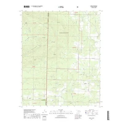
2019 Map of Zafra
USGS Topo · Published 2019About this map
The settlement of Zafra lies at the southwestern edge of this landscape, positioned near the border between Oklahoma and Arkansas. This area is defined by the dense network of ridges and peaks within the Ouachita National Forest, where steep terrain funnels numerous named branches and creeks toward the Mountain Fork. Historically significant landmarks like the Mountain Fork Bridge and the Gann Cem or Stinett Cem indicate early patterns of movement and burial in a region where travel followed the natural contours of the land. The proximity of Turkey Snout Ridge, Polecat Peak, and Cow Creek Mtn illustrates the difficult topography that isolated these mountain communities. Local transport routes such as Polk Road 159 and Zafra Rd connect these remote points, tracing the valleys of Slate Cr and Choctaw Cr.
Find a feature on this map
71 named features on this map. Tap any name to fly to it.
Don’t see what you’re looking for? This feature index may not catch every label — zoom into the map to look around manually.
Map Details
Editions of this 2019 Zafra Map
This is the sole edition of this map. No revisions or reprints were ever made.
Other maps of this area

1890 · Poteau Mountain
USGS Topo · 1:125,000

1899 · Poteau Mountain
USGS Topo · 1:125,000

1900 · Winding Stair
USGS Topo · 1:125,000

1902 · Lukfata
USGS Topo · 1:125,000

1909 · Winding Stair
USGS Topo · 1:125,000

1913 · De Queen
USGS Topo · 1:125,000

1950 · Mcalester
USGS Topo · 1:250,000

1958 · Potter
USGS Topo · 1:62,500

1958 · Zafra
USGS Topo · 1:24,000

1958 · Rich Mountain
USGS Topo · 1:24,000