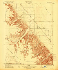
1916 Map of Zamora
USGS Topo · Published 1920About this map
Zamora and its surrounding agricultural landscape appear here during the early twentieth century, defined by a sharp transition between the dissected hills and the flatlands of the Colusa Basin. The Southern Pacific railroad’s (Woodland Line) cuts diagonally across the eastern half of the map, serving as the primary infrastructure for the small rail stops of Bretona and Wycoff. This corridor provided essential transport for the region's farms, linking the rural grain and fruit production areas to larger markets.
Find a feature on this map
14 named features on this map. Tap any name to fly to it.
Don’t see what you’re looking for? This feature index may not catch every label — zoom into the map to look around manually.
Map Details
Editions of this 1916 Zamora Map
2 editions found

Other maps of this area

1905 · Harrington
USGS Topo · 1:24,000

1905 · Esparto
USGS Topo · 1:24,000

1907 · Dunnigan
USGS Topo · 1:62,500

1907 · Woodland
USGS Topo · 1:62,500

1915 · Yolo
USGS Topo · 1:31,680

1915 · Ronda
USGS Topo · 1:31,680
1915 · Kirkville
USGS Topo · 1:31,680

1916 · Jacobs Corner
USGS Topo · 1:31,680

1916 · Harrington
USGS Topo · 1:31,680

1916 · Hershey
USGS Topo · 1:31,680