
1916 Map of Zamora
USGS Topo · Published 1916About this map
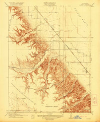
Zamora stands as a central railway hub on this 1916 survey, situated along the Southern Pacific tracks in a landscape defined by the transition from the Sacramento Valley floor to the surrounding uplands. The Woodland Line road and the Mt Diablo Meridian provide a rigid geometric grid that contrasts with the sinuous drainage patterns of Bird Creek and Oat Creek. These watercourses carve through the terrain, emerging from Oat Valley to meet the wide, flat expanse of the Colusa Basin. Smaller rail stops and settlements like Wycoff and Bretona illustrate the early twentieth-century reliance on the railroad for agricultural transport. A notable survey detail is the western portion of the sheet, which indicates that more detailed elevation data was deferred to a separate sheet, leaving a portion of the hilly terrain above Cottonwood Spring simplified compared to the intricately contoured central ridges.
Find a feature on this map
14 named features on this map. Tap any name to fly to it.
Don’t see what you’re looking for? This feature index may not catch every label — zoom into the map to look around manually.
Map Details
Editions of this 1916 Zamora Map
2 editions found
Other maps of this area

1905 · Harrington
USGS Topo · 1:24,000

1905 · Esparto
USGS Topo · 1:24,000

1907 · Dunnigan
USGS Topo · 1:62,500

1907 · Woodland
USGS Topo · 1:62,500

1915 · Yolo
USGS Topo · 1:31,680

1915 · Ronda
USGS Topo · 1:31,680
1915 · Kirkville
USGS Topo · 1:31,680

1916 · Jacobs Corner
USGS Topo · 1:31,680

1916 · Harrington
USGS Topo · 1:31,680

1916 · Hershey
USGS Topo · 1:31,680