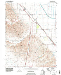
1992 Map of Zamora
USGS Topo · Published 1997About this map
The Dunnigan Hills Gas Field dominates the western half of this landscape, where the rising terrain of the Dunnigan Hills meets the agricultural flats of the Sacramento Valley. This 1990s-era documentation shows a region defined by complex drainage systems and energy extraction. The eastern portion is notably flat, characterized by the engineered path of the Colusa Basin Drainage Canal and the clustered settlement at Zamora.
Find a feature on this map
13 named features on this map. Tap any name to fly to it.
Don’t see what you’re looking for? This feature index may not catch every label — zoom into the map to look around manually.
Map Details
Editions of this 1992 Zamora Map
2 editions found
Other maps of this area

1905 · Harrington
USGS Topo · 1:24,000

1905 · Esparto
USGS Topo · 1:24,000

1907 · Dunnigan
USGS Topo · 1:62,500

1907 · Woodland
USGS Topo · 1:62,500

1915 · Yolo
USGS Topo · 1:31,680

1915 · Ronda
USGS Topo · 1:31,680
1915 · Kirkville
USGS Topo · 1:31,680

1916 · Jacobs Corner
USGS Topo · 1:31,680

1916 · Harrington
USGS Topo · 1:31,680

1916 · Hershey
USGS Topo · 1:31,680