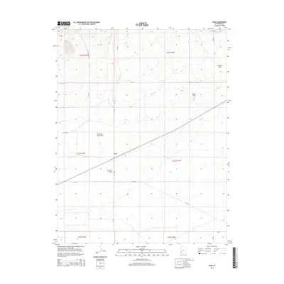
2014 Map of Zane
USGS Topo · Published 2014About this map
Zane stands as a distinct railroad point along the Union Pacific Railroad in southwestern Utah, where the tracks slice diagonally across the arid expanse of the Escalante Desert. This 2014 survey reveals a landscape primarily defined by its drainage systems and geological features, including the prominent Black Reef and the winding course of Mountain Spring Wash. The area is marked by a rigorous section-line road network, featuring routes such as Lehi Wood Trl and Pine Valley Rd that provide access through the remote desert terrain. The convergence of these utilitarian roads with the long-established rail corridor highlights the region's role as a transit path between mountain ranges. Genealogists and historians can trace the precise intersection of early 21st-century infrastructure with natural landmarks like Fourmile Wash, documenting the persistent character of this desert settlement.
Find a feature on this map
21 named features on this map. Tap any name to fly to it.
Don’t see what you’re looking for? This feature index may not catch every label — zoom into the map to look around manually.
Map Details
Editions of this 2014 Zane Map
This is the sole edition of this map. No revisions or reprints were ever made.
Other maps of this area

1885 · St. George
USGS Topo · 1:250,000

1891 · St. George
USGS Topo · 1:250,000

1950 · Antelope Peak
USGS Topo · 1:24,000

1951 · Avon NW
USGS Topo · 1:24,000

1953 · Richfield
USGS Topo · 1:250,000

1953 · Cedar City
USGS Topo · 1:250,000

1958 · Richfield
USGS Topo · 1:250,000

1958 · Cedar City
USGS Topo · 1:250,000

1962 · Cedar City
USGS Topo · 1:250,000
1971 · Lund
USGS Topo · 1:24,000