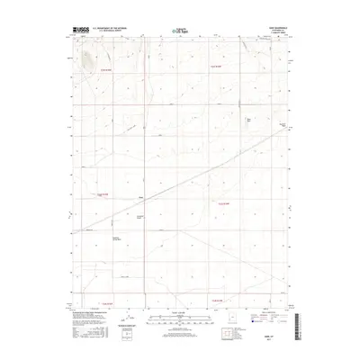
2017 Map of Zane
USGS Topo · Published 2017About this map
The settlement of Zane sits at the heart of this Iron County landscape, positioned within the expansive terrain of the Escalante Desert. This desert environment is defined by its wide basins and seasonal drainages, most notably the Fourmile Wash and Mountain Spring Wash, which cut through the arid valley floor. A sense of connectivity is established by local routes such as Lehi Wood - Zane and Popeline Dr, illustrating the infrastructure required to navigate this portion of southwestern Utah. To the northeast, the topographical rise of Black Reef provides a distinct geological break from the surrounding flats. The map documents the persistent layout of grazing lands and rural access roads, including Lund Pasture and Mountain Spring Rd, highlighting the region's enduring character as a sparsely populated agricultural and desert expanse.
Find a feature on this map
17 named features on this map. Tap any name to fly to it.
Don’t see what you’re looking for? This feature index may not catch every label — zoom into the map to look around manually.
Map Details
Editions of this 2017 Zane Map
This is the sole edition of this map. No revisions or reprints were ever made.
Other maps of this area

1885 · St. George
USGS Topo · 1:250,000

1891 · St. George
USGS Topo · 1:250,000

1950 · Antelope Peak
USGS Topo · 1:24,000

1951 · Avon NW
USGS Topo · 1:24,000

1953 · Richfield
USGS Topo · 1:250,000

1953 · Cedar City
USGS Topo · 1:250,000

1958 · Richfield
USGS Topo · 1:250,000

1958 · Cedar City
USGS Topo · 1:250,000

1962 · Cedar City
USGS Topo · 1:250,000
1971 · Lund
USGS Topo · 1:24,000