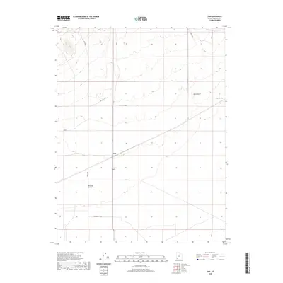
2020 Map of Zane
USGS Topo · Published 2020About this map
The Zane settlement sits along the Union Pacific railroad line, serving as a critical infrastructure point within the arid expanse of the Escalante Desert. This 2020 survey illustrates a landscape defined by industrial transit and cattle ranching, where remote tracks like Lehi Wood Trl and Lehi Wood - Zane navigate the wide alluvial plains. To the east, the topography shifts at Black Reef, a distinct formation overlooking the drainage of Fourmile Wash. The mapping of named cattle ranges such as Lund Pasture and seasonal watercourses like Mountain Spring Wash indicates the continued importance of water management and land use in this part of Iron County. The rail line remains the primary corridor, slicing diagonally through the desert and connecting the small outpost of Zane to the broader regional network.
Find a feature on this map
11 named features on this map. Tap any name to fly to it.
Don’t see what you’re looking for? This feature index may not catch every label — zoom into the map to look around manually.
Map Details
Editions of this 2020 Zane Map
This is the sole edition of this map. No revisions or reprints were ever made.
Other maps of this area

1885 · St. George
USGS Topo · 1:250,000

1891 · St. George
USGS Topo · 1:250,000

1950 · Antelope Peak
USGS Topo · 1:24,000

1951 · Avon NW
USGS Topo · 1:24,000

1953 · Richfield
USGS Topo · 1:250,000

1953 · Cedar City
USGS Topo · 1:250,000

1958 · Richfield
USGS Topo · 1:250,000

1958 · Cedar City
USGS Topo · 1:250,000

1962 · Cedar City
USGS Topo · 1:250,000
1971 · Lund
USGS Topo · 1:24,000