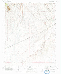
1972 Map of Zane
USGS Topo · Published 1976About this map
The Union Pacific railroad cuts a diagonal line across this arid Iron County landscape, anchoring the small settlement of Zane. In this early 1970s environment, the railroad serves as the primary infrastructure connecting the high desert terrain with the broader regional network. The topography is defined by the drainage of Mountain Spring Wash, which carries seasonal runoff from the higher elevations to the north toward the flatter basins below. To the east, the prominent geologic formation of Black Reef stands as a distinct landmark against the surrounding slopes. This survey also records the location of Wells, indicating the critical importance of water access for ranching or railroad operations in this corner of Utah. Transport across the terrain is limited to the rail line and the primitive Pine Valley Road, illustrating the sparse, utility-focused development of the area at the time.
Find a feature on this map
7 named features on this map. Tap any name to fly to it.
Don’t see what you’re looking for? This feature index may not catch every label — zoom into the map to look around manually.
Map Details
Editions of this 1972 Zane Map
This is the sole edition of this map. No revisions or reprints were ever made.
Other maps of this area

1885 · St. George
USGS Topo · 1:250,000

1891 · St. George
USGS Topo · 1:250,000

1950 · Antelope Peak
USGS Topo · 1:24,000

1951 · Avon NW
USGS Topo · 1:24,000

1953 · Richfield
USGS Topo · 1:250,000

1953 · Cedar City
USGS Topo · 1:250,000

1958 · Richfield
USGS Topo · 1:250,000

1958 · Cedar City
USGS Topo · 1:250,000

1962 · Cedar City
USGS Topo · 1:250,000
1971 · Lund
USGS Topo · 1:24,000