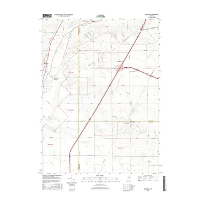
2016 Map of Zanesville
USGS Topo · Published 2016About this map
Roanoke and Zanesville anchor this 2016 survey of the tri-county borderlands where Huntington, Allen, and Wells counties meet. The landscape is defined by a dense network of agricultural drainage and natural waterways, including the Little River and Aboite Creek. The presence of Roanoke Station and the cross-county transit corridors highlight the area's role as a connection point between regional hubs. Local history is preserved in family and community burial sites such as Hoverstock Cem near Zanesville and Saint Johns Cem to the south. The intricate grid of rural roads, including Hosler Rd and Kress Rd, illustrates the persistent township-and-range division of the Indiana countryside. Significant water management features like Pleasant Run Ditch and the Graham-McCulloch Ditch Number Four reveal the extensive engineering required to maintain the productivity of this glaciated terrain.
Find a feature on this map
85 named features on this map. Tap any name to fly to it.
Don’t see what you’re looking for? This feature index may not catch every label — zoom into the map to look around manually.
Map Details
Editions of this 2016 Zanesville Map
This is the sole edition of this map. No revisions or reprints were ever made.
Other maps of this area

1952 · Majenica
USGS Topo · 1:24,000

1953 · Fort Wayne
USGS Topo · 1:250,000

1953 · Muncie
USGS Topo · 1:250,000

1955 · Markle
USGS Topo · 1:24,000

1956 · Muncie
USGS Topo · 1:250,000

1956 · Fort Wayne
USGS Topo · 1:250,000

1956 · Fort Wayne West
USGS Topo · 1:24,000

1956 · Huntington
USGS Topo · 1:24,000

1961 · Arcola
USGS Topo · 1:24,000
1961 · Laud
USGS Topo · 1:24,000