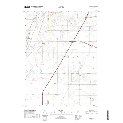
2019 Map of Zanesville
USGS Topo · Published 2019About this map
Zanesville sits at the intersection of three counties in this recent survey of northeastern Indiana, where the boundaries of Allen, Wells, and Huntington counties converge. The landscape is defined by the headwaters and drainage networks of the Little River, which winds near Roanoke and Roanoke Station in the west. This area serves as a significant drainage divide, characterized by an extensive system of agricultural waterways including Pleasant Run Ditch, Witzgall Ditch, and Johnson Ditch, which channel water toward the Eightmile Creek and Flat Cr basins.
Find a feature on this map
62 named features on this map. Tap any name to fly to it.
Don’t see what you’re looking for? This feature index may not catch every label — zoom into the map to look around manually.
Map Details
Editions of this 2019 Zanesville Map
This is the sole edition of this map. No revisions or reprints were ever made.
Other maps of this area

1952 · Majenica
USGS Topo · 1:24,000

1953 · Fort Wayne
USGS Topo · 1:250,000

1953 · Muncie
USGS Topo · 1:250,000

1955 · Markle
USGS Topo · 1:24,000

1956 · Muncie
USGS Topo · 1:250,000

1956 · Fort Wayne
USGS Topo · 1:250,000

1956 · Fort Wayne West
USGS Topo · 1:24,000

1956 · Huntington
USGS Topo · 1:24,000

1961 · Arcola
USGS Topo · 1:24,000
1961 · Laud
USGS Topo · 1:24,000