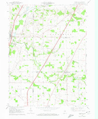
1972 Map of Zanesville
USGS Topo · Published 1974About this map
Zanesville and Roanoke anchor this 1972 survey, capturing a rural landscape defined by clear jurisdictional lines and drainage networks. The Old Indian Treaty Boundary cuts diagonally across the northwest corner, a significant historical surveyor's mark that still influenced land division decades later. This region, where Jackson, Lafayette, and Union townships meet, is threaded by the Norfolk and Western railroad and the slow-moving Little River.
Find a feature on this map
65 named features on this map. Tap any name to fly to it.
Don’t see what you’re looking for? This feature index may not catch every label — zoom into the map to look around manually.
Map Details
Editions of this 1972 Zanesville Map
This is the sole edition of this map. No revisions or reprints were ever made.
Other maps of this area

1952 · Majenica
USGS Topo · 1:24,000

1953 · Fort Wayne
USGS Topo · 1:250,000

1953 · Muncie
USGS Topo · 1:250,000

1955 · Markle
USGS Topo · 1:24,000

1956 · Muncie
USGS Topo · 1:250,000

1956 · Fort Wayne
USGS Topo · 1:250,000

1956 · Fort Wayne West
USGS Topo · 1:24,000

1956 · Huntington
USGS Topo · 1:24,000

1961 · Arcola
USGS Topo · 1:24,000
1961 · Laud
USGS Topo · 1:24,000