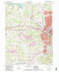
1992 Map of Zanesville West
USGS Topo · Published 1995About this map
The confluence of the Licking River and Muskingum River anchors this landscape, where the urban center of Zanesville transitions into the industrial and agricultural outskirts of Muskingum County. This 1990s record reflects the city's complex topography, from the residential blocks of North Zanesville and Licking View to the rising terrain of Owens Hills. The map captures a detailed inventory of local institutions, including the Good Samaritan Hospital, the County Fairground, and numerous educational sites like Hancock Jr High Sch and Putnam Hill Sch.
Find a feature on this map
111 named features on this map. Tap any name to fly to it.
Don’t see what you’re looking for? This feature index may not catch every label — zoom into the map to look around manually.
Map Details
Editions of this 1992 Zanesville West Map
This is the sole edition of this map. No revisions or reprints were ever made.
Other maps of this area

1908 · Conesville
USGS Topo · 1:62,500

1910 · Frazeysburg
USGS Topo · 1:62,500

1910 · Philo
USGS Topo · 1:62,500

1910 · Zanesville
USGS Topo · 1:62,500

1910 · Conesville
USGS Topo · 1:62,500

1947 · Columbus
USGS Topo · 1:250,000

1949 · Clarksburg
USGS Topo · 1:250,000

1950 · Marion
USGS Topo · 1:250,000

1951 · Canton
USGS Topo · 1:250,000

1953 · Canton
USGS Topo · 1:250,000