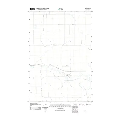
2011 Map of Zap
USGS Topo · Published 2011About this map
Zap serves as the central hub for this portion of Mercer County, oriented along a grid defined by 4th Ave and 3rd Ave. The town is positioned just south of the winding Spring Creek, which snakes through the prairie landscape alongside County Rd-13. The area's settlement history is marked by local burial sites, including the Zap Cemetery north of the village and the Engbrecht Cemetery located further southwest near County Rd-22. This 2011 survey reveals a landscape largely shaped by agricultural section lines, with major corridors like County Rd-26 and 67th Ave SW providing the primary structure for travel. In the northern reaches, the West Branch Antelope Creek drains the open country, illustrating the subtle hydrology of the North Dakota plains before the land rises toward the surrounding buttes.
Find a feature on this map
17 named features on this map. Tap any name to fly to it.
Don’t see what you’re looking for? This feature index may not catch every label — zoom into the map to look around manually.
Map Details
Editions of this 2011 Zap Map
This is the sole edition of this map. No revisions or reprints were ever made.
Other maps of this area

1953 · Watford City
USGS Topo · 1:250,000

1954 · McClusky
USGS Topo · 1:250,000

1957 · Watford City
USGS Topo · 1:250,000

1958 · McClusky
USGS Topo · 1:250,000

1967 · Watford City
USGS Topo · 1:250,000

1968 · Beulah
USGS Topo · 1:24,000

1968 · Medicine Butte NE
USGS Topo · 1:24,000

1968 · Medicine Butte
USGS Topo · 1:24,000

1969 · Beulah NE
USGS Topo · 1:24,000
1969 · Beulah NW
USGS Topo · 1:24,000