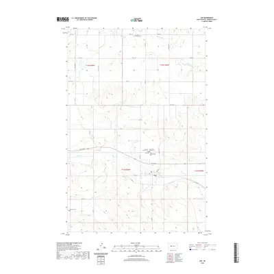
2020 Map of Zap
USGS Topo · Published 2020About this map
The small community of Zap serves as the focal point of this Mercer County landscape, situated along the path of Spring Cr. The map reveals a dense concentration of religious and genealogical sites just north of the town center, including Saint Luke's Lutheran Cem, Immanuel Lutheran Cem, and Peace Congregational Cem. These sites, along with the Zap Cem, reflect the heritage of the early 20th-century settlers who established these plains. The terrain is defined by the winding drainages of Spring Cr and the W Br Antelope Cr, with a grid of rural roads like Co RD 11 and Co RD 26 connecting isolated homesteads. To the south, the Engbrecht Cem sits alone, marking family history on the open prairie.
Find a feature on this map
31 named features on this map. Tap any name to fly to it.
Don’t see what you’re looking for? This feature index may not catch every label — zoom into the map to look around manually.
Map Details
Editions of this 2020 Zap Map
This is the sole edition of this map. No revisions or reprints were ever made.
Other maps of this area

1953 · Watford City
USGS Topo · 1:250,000

1954 · McClusky
USGS Topo · 1:250,000

1957 · Watford City
USGS Topo · 1:250,000

1958 · McClusky
USGS Topo · 1:250,000

1967 · Watford City
USGS Topo · 1:250,000

1968 · Beulah
USGS Topo · 1:24,000

1968 · Medicine Butte NE
USGS Topo · 1:24,000

1968 · Medicine Butte
USGS Topo · 1:24,000

1969 · Beulah NE
USGS Topo · 1:24,000
1969 · Beulah NW
USGS Topo · 1:24,000