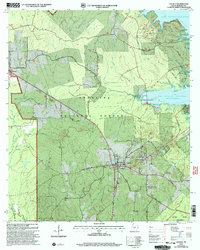
2003 Map of Zavalla
USGS Topo · Published 2004About this map
The Angelina National Forest dominates the landscape of this East Texas survey, where the sprawling waters of the Sam Rayburn Reservoir meet the piney woods. Centered on the town of Zavalla, the map reveals a network of rural roads often bearing family names, such as Roberts Road and Boulware Hudspeth Road. For genealogists, the map is a critical record of local burial sites, documenting Zavalla Cem, Townsend Cem, McNeil Cem, Ozias Cem, and Poland Cem.
Find a feature on this map
58 named features on this map. Tap any name to fly to it.
Don’t see what you’re looking for? This feature index may not catch every label — zoom into the map to look around manually.
Map Details
Editions of this 2003 Zavalla Map
This is the sole edition of this map. No revisions or reprints were ever made.
Other maps of this area

1928 · Zavalla 3-c
USGS Topo · 1:24,000

1928 · Lufkin 4-d
USGS Topo · 1:24,000

1931 · Zavalla
USGS Topo · 1:62,500

1932 · Manning
USGS Topo · 1:62,500

1949 · Lufkin
USGS Topo · 1:62,500

1949 · Huntington
USGS Topo · 1:24,000

1950 · Huntington
USGS Topo · 1:24,000

1953 · Palestine
USGS Topo · 1:250,000

1957 · Palestine
USGS Topo · 1:250,000

1958 · Zavalla
USGS Topo · 1:62,500