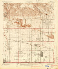
1941 Map of Zelzah
USGS Topo · Published 1941About this map
The San Fernando Valley was undergoing a significant transition from citrus and poultry ranching to suburban expansion when this survey was updated in the late 1930s. The landscape is defined by a rigid grid of streets like Devonshire Street and Saticoy Street, overlaying the historic boundaries of the Ex Mission San Fernando. Evidence of the area's specialized agricultural history is visible at the Runnymede Poultry Colony near Reseda, while the foothills of the Santa Susana Mountains show more secluded settlements like Twin Lakes and Marwyck Ranch. Transportation infrastructure anchors the region, with the Southern Pacific and the Pacific Electric lines connecting towns such as Chatsworth and Canoga Park to the wider Los Angeles basin. This document captures the moment when Zelzah Northridge PO and Sta was still a primary local hub before its mid-century development boom.
Find a feature on this map
40 named features on this map. Tap any name to fly to it.
Don’t see what you’re looking for? This feature index may not catch every label — zoom into the map to look around manually.
Map Details
Editions of this 1941 Zelzah Map
2 editions found
Other maps of this area

1894 · Los Angeles
USGS Topo · 1:62,500

1896 · Santa Monica
USGS Topo · 1:62,500

1898 · Santa Monica
USGS Topo · 1:62,500

1900 · Los Angeles
USGS Topo · 1:62,500

1900 · Fernando
USGS Topo · 1:62,500

1901 · Southern California Sheet No. 1
USGS Topo · 1:250,000

1902 · Santa Monica
USGS Topo · 1:62,500

1903 · Calabasas
USGS Topo · 1:62,500

1903 · Camulos
USGS Topo · 1:125,000

1903 · Santa Susana
USGS Topo · 1:62,500
Featured Places
- Los Angeles, CA
- Deer Lake Highlands, Unincorporated Chatsworth
- Unincorporated Chatsworth, CA
- Los Angeles County, CA
- United States