
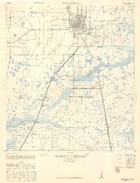
1947 Map of Zephyrhills
USGS Topo · Published 1947About this map
Zephyrhills is shown here as a developing hub in East Pasco County during the mid-1940s, marked by the significant footprint of the Zephyrhills Army Air Base situated just east of the main town grid. The landscape is defined by the convergence of the Atlantic Coast Line and Seaboard Air Line railroads, which facilitated the local citrus and timber economies. To the south, the Hillsborough River cuts through the terrain, flanked by the early boundaries of Hillsborough State Park and its Tower. Small rural pockets like Crystal Springs are documented with local essentials including the Crystal Springs School and Crystal Springs Cem. The presence of the State Highway Prison Camp near the Hillsborough River provides a glimpse into the era's regional infrastructure and labor systems.
Find a feature on this map
48 named features on this map. Tap any name to fly to it.
Don’t see what you’re looking for? This feature index may not catch every label — zoom into the map to look around manually.
Map Details
Editions of this 1947 Zephyrhills Map
2 editions found
Other maps of this area

1943 · Thonotosassa
USGS Topo · 1:24,000

1944 · Plant City
USGS Topo · 1:31,680

1944 · Wesley Chapel
USGS Topo · 1:31,680

1944 · Thonotosassa
USGS Topo · 1:31,680

1944 · Antioch
USGS Topo · 1:31,680

1944 · Socrum
USGS Topo · 1:31,680

1954 · San Antonio
USGS Topo · 1:24,000

1955 · Plant City
USGS Topo · 1:250,000

1958 · Plant City
USGS Topo · 1:250,000

1959 · Plant City
USGS Topo · 1:250,000
Featured Places
- Zephyrhills, FL
- Crystal Springs Colony Farms, FL
- Crystal Springs, FL
- Hillsborough County, FL
- Pasco County, FL