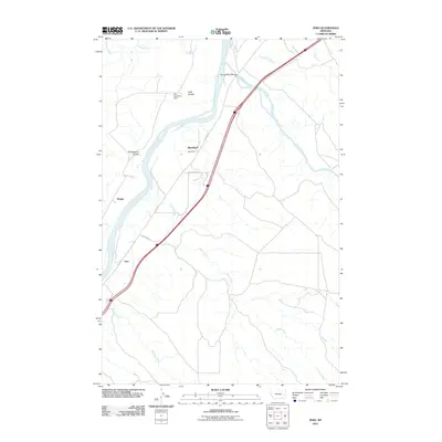
2011 Map of Zero
USGS Topo · Published 2011About this map
The confluence of the Powder River and the Yellowstone River serves as the focal point for this eastern Montana landscape, where the wide river valleys meet dissected plains. Small railway and road-side settlements like Zero, Blatchford, and Saugus trace the historical transportation corridors that defined settlement in Prairie County. The map documents a sparse, high-plains environment where water is the primary architect of the terrain, as seen in the numerous drainages such as Camp Creek, Williams Creek, and Custer Creek that feed into the main river systems.
Find a feature on this map
20 named features on this map. Tap any name to fly to it.
Don’t see what you’re looking for? This feature index may not catch every label — zoom into the map to look around manually.
Map Details
Editions of this 2011 Zero Map
This is the sole edition of this map. No revisions or reprints were ever made.
Other maps of this area

1953 · Miles City
USGS Topo · 1:250,000

1957 · Miles City
USGS Topo · 1:250,000

1958 · Miles City
USGS Topo · 1:250,000

1969 · Corral Butte
USGS Topo · 1:24,000

1969 · Spring Draw
USGS Topo · 1:24,000

1969 · Zero NE
USGS Topo · 1:24,000

1969 · Zero
USGS Topo · 1:24,000

1969 · Kinsey NE
USGS Topo · 1:24,000
1969 · Shirley
USGS Topo · 1:24,000

1972 · Calypso
USGS Topo · 1:24,000