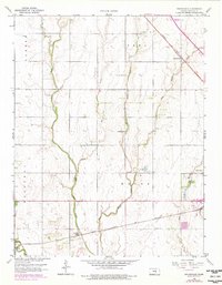
1959 Map of Zimmerdale
USGS Topo · Published 1979About this map
Zimmerdale stands as a rail-side settlement along the Missouri Pacific line in Harvey County, surrounded by a complex drainage system formed by the branches of Emma Creek. The landscape is defined by its agrarian and industrial infrastructure, ranging from the Weaver Ranch Airfield in the northeast to the Newton Waterworks and Sewage Disposal facilities near the Little Arkansas River in the southwest. A legacy of early settlement is visible in the distribution of rural landmarks like the Prouty Sch and several small burial grounds, including the Church of God Cem and Royer Cem. Transportation corridors are a primary feature of the area, with the Atchison Topeka and Santa Fe railroad cutting through the southern townships. Modern mid-century additions, such as the Drive-in Theater and local Golf Course, indicate the post-war transition of this agricultural region.
Find a feature on this map
23 named features on this map. Tap any name to fly to it.
Don’t see what you’re looking for? This feature index may not catch every label — zoom into the map to look around manually.
Map Details
Editions of this 1959 Zimmerdale Map
4 editions found
Other maps of this area

1889 · Newton
USGS Topo · 1:125,000

1889 · Cheney
USGS Topo · 1:125,000

1889 · Wichita
USGS Topo · 1:125,000

1891 · Hutchinson
USGS Topo · 1:125,000

1891 · Cheney
USGS Topo · 1:125,000

1893 · Hutchinson
USGS Topo · 1:125,000

1894 · Wichita
USGS Topo · 1:125,000

1894 · Newton
USGS Topo · 1:125,000

1901 · Cheney
USGS Topo · 1:125,000

1955 · Wichita
USGS Topo · 1:250,000