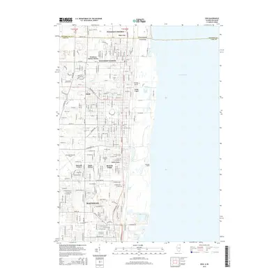
2015 Map of Zion
USGS Topo · Published 2015About this map
Lake Michigan dominates the eastern boundary of this coastal survey, where the Illinois-Wisconsin state line meets the shoreline north of Winthrop Harbor. The landscape is defined by the transition from the lake's edge across Farnum Point and into the wetlands and ravines of the interior, including Kellogg Ravine and the drainage of the Dead River. Residential and industrial development is concentrated in the southern portion near Waukegan and central Zion, while specialized sites like Camp Logan and Waukegan Regional Airport occupy the periphery. Genealogy researchers will find several well-defined burial grounds, such as Mount Olivet Memorial Park and the older Lake Mound Cem. The map tracks the rail corridor through Winthrop Harbor Station and Beach Station, highlighting the transportation spine that historically linked these lakefront communities.
Find a feature on this map
56 named features on this map. Tap any name to fly to it.
Don’t see what you’re looking for? This feature index may not catch every label — zoom into the map to look around manually.
Map Details
Editions of this 2015 Zion Map
This is the sole edition of this map. No revisions or reprints were ever made.
Other maps of this area

1892 · Racine
USGS Topo · 1:62,500

1905 · Racine
USGS Topo · 1:62,500

1906 · Waukegan
USGS Topo · 1:62,500

1908 · Waukegan
USGS Topo · 1:62,500
1958 · Kenosha
USGS Topo · 1:24,000
1958 · Pleasant Prairie
USGS Topo · 1:24,000

1958 · Racine
USGS Topo · 1:250,000
1959 · Racine
USGS Topo · 1:62,500
1960 · Waukegan
USGS Topo · 1:24,000
1960 · Zion
USGS Topo · 1:24,000