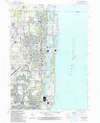
1993 Map of Zion
USGS Topo · Published 1993About this map
Illinois Beach State Park dominates the shoreline of Lake Michigan in this 1993 study, protecting a landscape of dunes and waterways like the Dead River and Dead Lake. The corridor between Winthrop Harbor and Zion is densely developed with civic and religious institutions, including Christian Ch and the Zion-Benton Twp High Sch. Transport infrastructure is prominent, from the Chicago and North Western rail line serving the Winthrop Harbor Station to the Waukegan Regional Airport in the south.
Find a feature on this map
81 named features on this map. Tap any name to fly to it.
Don’t see what you’re looking for? This feature index may not catch every label — zoom into the map to look around manually.
Map Details
Editions of this 1993 Zion Map
This is the sole edition of this map. No revisions or reprints were ever made.
Other maps of this area

1892 · Racine
USGS Topo · 1:62,500

1905 · Racine
USGS Topo · 1:62,500

1906 · Waukegan
USGS Topo · 1:62,500

1908 · Waukegan
USGS Topo · 1:62,500
1958 · Kenosha
USGS Topo · 1:24,000
1958 · Pleasant Prairie
USGS Topo · 1:24,000

1958 · Racine
USGS Topo · 1:250,000
1959 · Racine
USGS Topo · 1:62,500
1960 · Waukegan
USGS Topo · 1:24,000
1960 · Zion
USGS Topo · 1:24,000