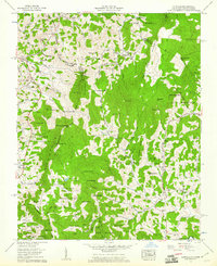
1959 Map of Zionville
USGS Topo · Published 1961About this map
The North Carolina Tennessee border runs through this 1950s landscape, where high ridgelines and deep creek valleys dictated the settlement of small farming communities. Along the state line, the community of Trade sits just west of Zionville, connected by the route of US Highway 421. The topography is dominated by massive features like Cove Creek Mountain and Rich Mountain Bald, which separate the various drainages including Meat Camp Creek and the North Fork New River.
Find a feature on this map
132 named features on this map. Tap any name to fly to it.
Don’t see what you’re looking for? This feature index may not catch every label — zoom into the map to look around manually.
Map Details
Editions of this 1959 Zionville Map
4 editions found
Other maps of this area

1893 · Cranberry
USGS Topo · 1:125,000

1895 · Cranberry
USGS Topo · 1:125,000

1899 · Cranberry
USGS Topo · 1:125,000

1902 · Cranberry
USGS Topo · 1:125,000

1934 · Valle Crucis
USGS Topo · 1:24,000

1934 · Boone
USGS Topo · 1:24,000

1935 · Baldwin Gap
USGS Topo · 1:24,000

1935 · Doe Mountain
USGS Topo · 1:48,000

1935 · Sherwood
USGS Topo · 1:24,000

1935 · Zionville
USGS Topo · 1:24,000