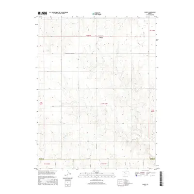
2015 Map of Zurich
USGS Topo · Published 2015About this map
Zurich sits at the intersection of Plainville Ave and Webster Lake Rd in a landscape defined by the rhythmic grid of township and section lines. This 2015 survey of Rooks County shows the small settlement near the Zurich Cem, reflecting the steady continuity of a High Plains farming community. The terrain is dissected by the meandering course of Sand Cr as it flows southeast toward the southern boundary. The inclusion of the Rooks Co Ellis Co line and roads like N Hampton-Fairview Township Rd provide clear points of reference for genealogists tracing family land holdings across several townships. The map documents the enduring infrastructure of rural Kansas, from well-maintained county roads to local watercourses.
Find a feature on this map
35 named features on this map. Tap any name to fly to it.
Don’t see what you’re looking for? This feature index may not catch every label — zoom into the map to look around manually.
Map Details
Editions of this 2015 Zurich Map
This is the sole edition of this map. No revisions or reprints were ever made.
Other maps of this area

1893 · Hill
USGS Topo · 1:125,000

1896 · Plainville
USGS Topo · 1:125,000

1955 · Beloit
USGS Topo · 1:250,000

1959 · Beloit
USGS Topo · 1:250,000
1963 · Hill City 4 SE
USGS Topo · 1:24,000

1969 · Palco
USGS Topo · 1:24,000

1969 · Stockton SW
USGS Topo · 1:24,000

1978 · Plainville
USGS Topo · 1:24,000
1978 · Plainville SW
USGS Topo · 1:24,000
1978 · Zurich
USGS Topo · 1:24,000