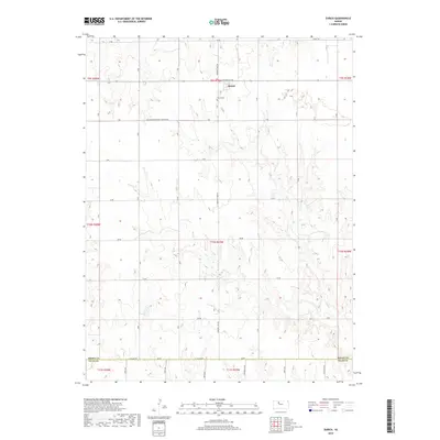
2018 Map of Zurich
USGS Topo · Published 2018About this map
Zurich sits atop the high plains of Rooks County, positioned along the intersection of Plainville Ave and Webster Lake RD. This 2018 survey reveals a landscape strictly defined by the Public Land Survey System, with a rigid grid of gravel and section roads like N Hampton-Fairview Township RD and Aa RD carving through the terrain. The small community is anchored by the Zurich Cem to the south, while the topography to the east and south becomes increasingly dissected by the drainage of Sand Cr. This drainage pattern contrasts sharply with the flat, upland agricultural blocks that dominate the northern and western sections of the township. Along the southern edge, the map documents the administrative transition at N Co Line RD, marking the boundary between Rooks and Ellis counties.
Find a feature on this map
24 named features on this map. Tap any name to fly to it.
Don’t see what you’re looking for? This feature index may not catch every label — zoom into the map to look around manually.
Map Details
Editions of this 2018 Zurich Map
This is the sole edition of this map. No revisions or reprints were ever made.
Other maps of this area

1893 · Hill
USGS Topo · 1:125,000

1896 · Plainville
USGS Topo · 1:125,000

1955 · Beloit
USGS Topo · 1:250,000

1959 · Beloit
USGS Topo · 1:250,000
1963 · Hill City 4 SE
USGS Topo · 1:24,000

1969 · Palco
USGS Topo · 1:24,000

1969 · Stockton SW
USGS Topo · 1:24,000

1978 · Plainville
USGS Topo · 1:24,000
1978 · Plainville SW
USGS Topo · 1:24,000
1978 · Zurich
USGS Topo · 1:24,000