1940s Maps of Puerto Rico
Explore 233 historic maps of Puerto Rico from the 1940s. These maps offer a rare glimpse into what life looked like during the 1940s — showing old roads, neighborhoods, homes, and landmarks that have changed or disappeared over time.
Whether you're researching your family's past, planning a metal detecting trip, or studying how Puerto Rico's landscape evolved across the 1940s, these high-resolution maps are a powerful tool for exploring the history of this region.
- Focus on a specific era: All maps on this page are from the 1940s, giving you a focused view of this time period.
- See what’s changed: Compare century-old streets, trails, and buildings to today's modern landscape using overlays and satellite layers.
- Research with precision: Use these maps for genealogy, historical research, land use analysis, or educational projects.
- View, download, or print: Maps are fully viewable online in high resolution, and can be downloaded or printed for your own records.
Start exploring Puerto Rico's history through authentic maps from the 1940s. This is your window into the past.
Puerto Rico maps
(233)- 1940 Map of Carolina
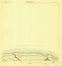
 1940 Carolina1940 Print · USGSNortheast Puerto Rico is shown here just before the era of rapid modernization, when sugar production dominated the coastal plains. Researchers can trace the layout of agricultural colonies like Colonia Monserrate and historic centers such as Loiza Aldea and Central Victoria.
 - 1940 Map of Vega Alta
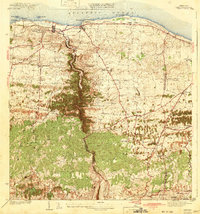
 1940 Vega Alta1940 Print · USGSThe northern coast of Puerto Rico was an industrial powerhouse of sugar production and rail transit in the years leading up to the second World War. Genealogists and historians can trace the footprint of the sugar economy through Central Constancia and the American Railroad of Porto Rico.2 unique versions available
 - 1941 Map of Bayamon
 1941 Bayamon1941 Print · USGSBayamón and the northern coast of Puerto Rico appear here in the early 1940s as a landscape of sugar centrales and rail lines. Genealogists and historians can trace family locations through numerous named colonias and landmarks like Central Juanita, Colonia La Monserrate, and Iglesia Cristo Rey.2 unique versions available
 - 1941 Map of San Juan
 1941 San Juan1941 Print · USGSSan Juan and its surrounding municipios are captured here in the early 1940s, showing the capital's expansion before the post-war industrial boom. Researchers can trace the layout of early suburbs like Hato Rey, locate landmarks like the Universidad de Puerto Rico, or study the historic fortifications at Morro Castle.2 unique versions available
 - 1941 Map of Moca
 1941 Moca1941 Print · USGSNorthwestern Puerto Rico is captured here in the early 1940s, showing a landscape where the coastal railroad meets the high ridges of the Cordillera. Researchers can trace the American RR of Porto Rico line through Estacion Santiago and find local landmarks like the Iglesia de la Virgen del Rosario.
 - 1941 Map of Rincon
 1941 Rincon1941 Print · USGSCoastal western Puerto Rico in the early 1940s reveals a bustling landscape defined by the sugar industry and the sea. Trace the American Railroad of Puerto Rico as it links Rincón to major mills like Central Igualdad and Central Coloso.
 - 1941 Map of San German
 1941 San German1941 Print · USGSThe hills and valleys surrounding San Germán come alive in this early 1940s survey, showing the peak of the railroad era in southwest Puerto Rico. Researchers can trace the American Railroad of Porto Rico through a landscape of historic estates like Hacienda Beatriz Soledad and Hacienda Resolucion.5 unique versions available
 - 1941 Map of Puerto Real
 1941 Puerto Real1941 Print · USGSCoastal life in southwestern Puerto Rico centered on the harbor at Puerto Real and the rail line at Cabo Rojo during the late thirties and early forties. Local historians can trace the American Railroad corridor and locate old landmarks like Cementerio Delicias and the salt works at Las Salinas.4 unique versions available
 - 1941 Map of Rio Grande
 1941 Rio Grande1941 Print · USGSCoastal Puerto Rico in the early 1940s reveals a landscape of tidal marshes and agricultural estates. Genealogists and researchers can trace family lands through the numerous named colonias like Colonia Blasini and Colonia Dolores, or locate early settlements such as Poblado Honduras.2 unique versions available
 - 1941 Map of Rincon
 1941 Rincon1941 Print · USGSWestern Puerto Rico’s sugar economy is at its peak in the early 1940s, showing the intricate network of plantations and rails between the coast and the mountains. Genealogists can trace family lands through named estates like Colonia Dolores or follow the American Railroad of Puerto Rico through Añasco.
 - 1941 Map of Isabela
 1941 Isabela1941 Print · USGSThe northern coast of Puerto Rico is captured here in the late thirties, when rail travel was still the backbone of local transit. Genealogists and historians can trace the early layout of Isabela, the route of the RR of PR, and local landmarks like San Antonio.5 unique versions available
 - 1941 Map of San Sebastian
 1941 San Sebastian1941 Print · USGSWestern Puerto Rico is captured here in the early 1940s, highlighting the agricultural heartbeat and social centers of the interior. Researchers can trace historic family-named estates like Hacienda San Pedro and Hacienda Espino or locate the industrial Central Soler.5 unique versions available
 - 1941 Map of Sabana Grande
 1941 Sabana Grande1941 Print · USGSSouthwest Puerto Rico in the late 1930s shows a landscape of rail-dependent agriculture and highland settlements. Researchers can trace the American Railroad of Porto Rico through stops at Estacion Limon and Fraternidad near the edge of the Laguna de Guanica.5 unique versions available
 - 1941 Map of Carolina
 1941 Carolina1941 Print · USGSCoastal Puerto Rico at the start of the 1940s shows a landscape of sugar centrales and traditional settlements along the Atlantic. Researchers can trace family ties at Loiza Aldea, locate the rail spurs of Central Victoria, or explore the limits of the Bosque Insular de Piñones.
 - 1941 Map of Rosario, 1952 Print
 1941 Rosario1952 Print · USGSWestern Puerto Rico's mountain interior comes alive in this mid-century survey of the Rosario region. Researchers can trace ancestral lands through numerous named estates like Hacienda Juanita and Hacienda Esperanza, or locate early community centers such as Limon and Iglesia de San Jose.2 unique versions available
 - 1942 Map of Moca
 1942 Moca1942 Print · USGSNorthwestern Puerto Rico during the early forties shows a landscape transitioning between coastal rail industry and the rural interior. Genealogists can trace family footprints near Jobos and the American R. R. of Porto Rico or at the Escuela Segunda Unidad de Voladoras.5 unique versions available
 - 1942 Map of Manati
 1942 Manati1942 Print · USGSThe northern coast of Puerto Rico during the early forties reveals a landscape of industrial sugar production and historic municipal centers. Genealogists and local historians can trace family roots through named settlements like Colonia El Pueblito or locate the historic Capilla de la Virgen del Carmen near Manati.2 unique versions available
 - 1942 Map of Central La Plata
 1942 Central La Plata1942 Print · USGSWestern Puerto Rico during the early 1940s reveals a landscape of sugar production and family estates centered around the Rio Grande de Añasco. Researchers can trace the industrial footprint of Central La Plata and locate traditional plantations such as Hacienda Esperanza and Hacienda Casen.6 unique versions available
 - 1942 Map of Arecibo
 1942 Arecibo1942 Print · USGSCoastal Arecibo and its surrounding sugar lands appear in detail during the early 1940s, when the rail lines were the lifeblood of the region. Genealogists and historians can trace the neighborhoods of Arecibo or locate families near the Central Cambalache and Estacion Arecibo.2 unique versions available
 - 1942 Map of Rosario
 1942 Rosario1942 Print · USGSWestern Puerto Rico is captured here in the era before widespread urbanization, showing the mountainous agricultural estates and early rail infrastructure. Genealogists can trace family holdings at Hacienda Esperanza or locate landmarks like the Hospital de Tuberculosis and American R. R.3 unique versions available
 - 1942 Map of Camuy
 1942 Camuy1942 Print · USGSThe northern coast of Puerto Rico is seen here during the pre-war era, where the coastal railroad linked bustling towns to the agricultural interior. Genealogists can trace family footprints through rural neighborhoods like Pueblo Nuevo and landmarks such as Iglesia Santa Teresita or Estacion Luchi.6 unique versions available
 - 1942 Map of Aguadilla
 1942 Aguadilla1942 Print · USGSCoastal life in northwest Puerto Rico during the early 1940s centered on the rail lines and rivers of the Aguadilla region. Genealogists and historians can trace family roots through the numerous railroad stops of the American Railroad or locate historical landmarks like the Pta Borinquen L H and the Iglesia Aguadilla.5 unique versions available
 - 1942 Map of Barceloneta
 1942 Barceloneta1942 Print · USGSNorthern Puerto Rico’s sugar-driven economy is at its peak in the early 1940s, centered around the towns and massive centrals. Researchers can trace the extensive sugar rail network including the American Railroad of Puerto Rico and visit old communities like Palmas Altas and Central Plazuela.2 unique versions available
 - 1943 Map of Utuado NE
 1943 Utuado NE1943 Print · USGSThe Puerto Rican interior during the early 1940s reveals a landscape of steep ridges and critical water resources near the Arecibo border. Researchers can trace rural life through landmarks like Escuela Del Valle, Escuela Morales, and the shoreline of Lago Dos Bocas.
 - 1943 Map of Island Of Vieques, 1946 Print
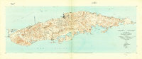 1943 Island Of Vieques1946 Print · USGSVieques during the 1940s reveals a maritime and agricultural landscape shaped by its barrios and coastal colonies. Trace the layout of Isabel Segunda, the agricultural sites at Colonia Lujan, and landmarks like Pta Mulas Faro.2 unique versions available
Showing maps 1-25 of 233
Top regions of Puerto Rico
- San Juan historical maps
- Bayamón historical maps
- Carolina historical maps
- Ponce historical maps
- Caguas historical maps
- Guaynabo historical maps
See more
Top cities of Puerto Rico
- San Juan historical maps
- Bayamón historical maps
- Carolina historical maps
- Ponce historical maps
- Caguas historical maps
- Guaynabo historical maps
See more
Frequently asked questions
- What are the different types of historical maps available for Puerto Rico?
- What is the oldest map of Puerto Rico?
- Where can I purchase historical maps of Puerto Rico for my home or office?
- Where can I download high-res historical maps of Puerto Rico?
- Are there historical topographic maps available for Puerto Rico?
- Is there historical aerial imagery available for Puerto Rico?
- Where are historical maps of Puerto Rico sourced from?