1960s Maps of Puerto Rico
Explore 57 historic maps of Puerto Rico from the 1960s. These maps offer a rare glimpse into what life looked like during the 1960s — showing old roads, neighborhoods, homes, and landmarks that have changed or disappeared over time.
Whether you're researching your family's past, planning a metal detecting trip, or studying how Puerto Rico's landscape evolved across the 1960s, these high-resolution maps are a powerful tool for exploring the history of this region.
- Focus on a specific era: All maps on this page are from the 1960s, giving you a focused view of this time period.
- See what’s changed: Compare century-old streets, trails, and buildings to today's modern landscape using overlays and satellite layers.
- Research with precision: Use these maps for genealogy, historical research, land use analysis, or educational projects.
- View, download, or print: Maps are fully viewable online in high resolution, and can be downloaded or printed for your own records.
Start exploring Puerto Rico's history through authentic maps from the 1960s. This is your window into the past.
Puerto Rico maps
(57)- 1960 Map of Isabela, 1961 Print
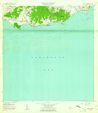
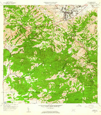
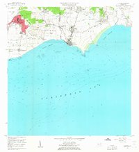
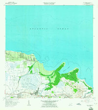
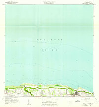 1960 Isabela1961 Print · USGSThe northwestern coast of Puerto Rico is captured here in the early sixties, showing the intersection of local town life and major military installations. Researchers can trace the perimeter of Ramey Air Force Base and locate family homesites within Jobos, Bejucos, and the Isabela town center.4 unique versions available
 - 1960 Map of Yabucoa, 1961 Print
 1960 Yabucoa1961 Print · USGSSoutheastern Puerto Rico is mapped here in the early sixties, showing the vital sugar industry and mountain settlements before modern expansion. Genealogists can locate family sites like Laura and Columbia, or local institutions such as Escuela Matías Sánchez and Central Roig.3 unique versions available
 - 1960 Map of Jayuya, 1961 Print
 1960 Jayuya1961 Print · USGSThe Cordillera Central around Jayuya is documented here in the early sixties, showing a landscape of coffee haciendas and steep peaks. Researchers can trace historic estates like Hacienda Jurutungo and Hacienda Los Planes or locate the high elevations of Cerro de Punta.3 unique versions available
 - 1960 Map of Maricao, 1961 Print
 1960 Maricao1961 Print · USGSThe mountains of western Puerto Rico are captured here in the early sixties, showing the agricultural heritage of Maricao. Genealogists can trace family lands across Hacienda Lealtad, Hacienda Santa Rita, and Pueblo Nuevo.3 unique versions available
 - 1960 Map of Punta Tuna, 1961 Print
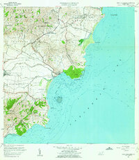
 1960 Punta Tuna1961 Print · USGSSoutheast Puerto Rico meets the sea in the early sixties, showing the transition from mountain ridges to the Caribbean coast. Genealogists and historians can trace the estates of Hacienda San Isidro, the landmark Faro Punta Tuna, and the village of Recio.2 unique versions available
 - 1960 Map of Adjuntas, 1962 Print
 1960 Adjuntas1962 Print · USGSThe high mountain terrain of the Cordillera Central comes to life in the early 1960s, showing the intersection of coffee estate history and modern hydraulic engineering. Genealogists and historians can locate numerous family estates like Hacienda Tres Hermanas and community centers such as Iglesia de San Patricio.4 unique versions available
 - 1960 Map of Salinas, 1962 Print
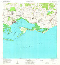
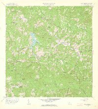
 1960 Salinas1962 Print · USGSThe southern coast of Puerto Rico is captured here in the early sixties, showing the agricultural and maritime life of the region. Researchers can trace land holdings like Hacienda Teresa or locate the mid-century Aeropuerto de Salinas.2 unique versions available
 - 1960 Map of Patillas, 1962 Print
 1960 Patillas1962 Print · USGSSoutheast Puerto Rico's mountain interior and the municipality of Patillas are captured here in the early sixties. Researchers can trace the layout of rural mountain life through landmarks like Campamento Guavate and Campamento Real.2 unique versions available
 - 1960 Map of Punta Guayanes, 1962 Print
 1960 Punta Guayanes1962 Print · USGSThe Yabucoa coastline in the early sixties reveals a landscape shaped by sugar production and rural commerce. Genealogists and historians can locate former schools like Escuela Asunción Lopez and trace the sugar infrastructure of Central Roig.6 unique versions available
 - 1960 Map of Central Aguirre, 1962 Print
 1960 Central Aguirre1962 Print · USGSThe sugar-producing coast of southern Puerto Rico comes alive in this mid-century survey of the Central Aguirre region. Genealogists can trace family roots through settlements like Coquí and San Felipe or locate local landmarks like the Colegio del Perpetuo Socorro and Central Guamaní.2 unique versions available
 - 1960 Map of Aguadilla, 1962 Print
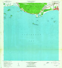
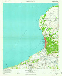 1960 Aguadilla1962 Print · USGSCoastal Aguadilla and the surrounding municipios are shown during a period of significant growth at the start of the 1960s. Researchers can trace the layout of Ramey Air Force Base, find local landmarks like Colegio San Carlos, or follow the Via Del Ferrocarril through Aguada.5 unique versions available
 - 1960 Map of Santa Isabel, 1962 Print
 1960 Santa Isabel1962 Print · USGSThe southern coast of Puerto Rico comes alive in this mid-century survey of the plains between the mountains and the Caribbean. Researchers can trace the layout of Central Cortada, find the locations of Hacienda Florida and Hacienda Alomar, or locate the Aeropuerto de Santa Isabel.2 unique versions available
 - 1960 Map of Cayey, 1962 Print
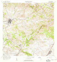
 1960 Cayey1962 Print · USGSCayey was transitioning from an agrarian mountain outpost to a regional hub during the early sixties. Genealogists can trace family footprints across several named estates, including Hacienda Julia and Hacienda Clavell, and locate old landmarks like the Capilla de Santa Marta.
 - 1960 Map of Monte Guilarte, 1962 Print
 1960 Monte Guilarte1962 Print · USGSThe central highlands of Adjuntas and Lares are shown here in the early 1960s, a landscape defined by traditional mountain agriculture. Genealogists and historians can trace scores of family estates and rural institutions, from Hacienda Monserrate and Hacienda Buena Vista to the Escuela Mariana Bracetti.4 unique versions available
 - 1960 Map of Rio Descalabrado, 1962 Print
 1960 Rio Descalabrado1962 Print · USGSCoastal plains and foothills near Santa Isabel and Juana Díaz are captured here during a period of agricultural and military significance. Researchers can trace historic estate boundaries at Hacienda Miranda and Hacienda Altura or locate local centers like Paso Seco.2 unique versions available
 - 1960 Map of Coamo, 1962 Print
 1960 Coamo1962 Print · USGSThe southern foothills of the Cordillera Central come into focus in the early sixties, centered on the growing town of Coamo. Researchers can locate historic agricultural sites like Hacienda Buena Vista or trace the boundaries of the Salinas Training Area.2 unique versions available
 - 1960 Map of Guayama, 1962 Print
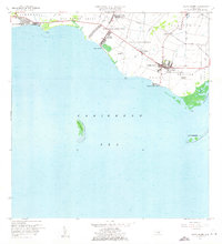
 1960 Guayama1962 Print · USGSThe south coast of Puerto Rico in the 1960s reveals a region defined by its sugar industry and maritime trade. Researchers can trace family ties to landmarks like Central Lafayette, Hacienda Felicia, and the coastal lighthouse at Punta Figuras.2 unique versions available
 - 1962 Map of Punta Cucharas, 1964 Print
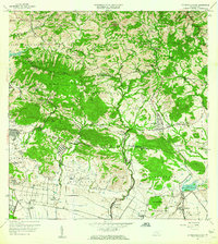
 1962 Punta Cucharas1964 Print · USGSThe southern coast of Puerto Rico comes into focus during the early sixties as urban expansion reaches toward the sea. Researchers can trace the heritage of Playa de Ponce, the site of Hacienda Matilde, and the route of the Antigua Vía del Ferrocarril.4 unique versions available
 - 1962 Map of Playa De Ponce, 1964 Print
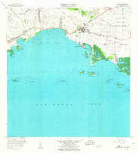
 1962 Playa De Ponce1964 Print · USGSThe Caribbean coast of southern Puerto Rico comes alive in this early 1960s survey, highlighting the bustling maritime hub at Playa de Ponce. Researchers can trace the waterfront around the Muelle de Ponce or explore offshore landmarks like Isla Caja de Muertos.
 - 1962 Map of Gurabo, 1965 Print
 1962 Gurabo1965 Print · USGSThe valleys and peaks of eastern Puerto Rico are captured here in the early sixties, showing the vital waterways of the Río Gurabo. Local historians can trace family locations at settlements like Mariana and Maria Jiménez or locate the Cementerio Rural de Gurabo.
 - 1962 Map of Fajardo, 1965 Print
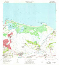
 1962 Fajardo1965 Print · USGSCoastal Fajardo and Luquillo appear in the early 1960s as the region balanced its fishing and maritime heritage with growing federal and municipal infrastructure. Trace the early boundaries of Puerto Real, the Roosevelt Roads Naval Reservation, and local schools like Escuela Rio Chiquito.6 unique versions available
 - 1963 Map of Carolina, 1965 Print
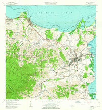
 1963 Carolina1965 Print · USGSThe coastal area east of San Juan comes to life in the early sixties, showing the vital waterways and growing barrios of the north shore. Genealogists and historians can locate family landmarks from Loiza Aldea to Canóvanas, including the Escuela Santa Catalina and the Hipodromo El Comandante.
 - 1963 Map of Rio Grande, 1965 Print
 1963 Rio Grande1965 Print · USGSCoastal Puerto Rico in the early sixties shows a landscape of growing barrios and winding rivers before modern development. Genealogists and historians can trace family roots in settlements like Suárez and Mini Mini or locate the Escuela Luis Calderón.4 unique versions available
 - 1963 Map of Bayamon, 1965 Print
 1963 Bayamon1965 Print · USGSBayamón and the surrounding coastal barrios are captured during a period of rapid development and military importance in the early sixties. Researchers can trace family roots through the Puerto Rico National Cemetery or locate historic industrial sites like Central Juanita and the Planta Termelectrica De Palo Seco.
 - 1963 Map of Naranjito, 1965 Print
 1963 Naranjito1965 Print · USGSNaranjito and the Puerto Rican interior are shown here during a period of rapid development in the 1960s. Researchers can trace rural school locations like Escuela Dajaos Sexto or explore the early power network at Planta Hidroeléctrica Comerío No 2.
Showing maps 1-25 of 57
Top regions of Puerto Rico
- San Juan historical maps
- Bayamón historical maps
- Carolina historical maps
- Ponce historical maps
- Caguas historical maps
- Guaynabo historical maps
See more
Top cities of Puerto Rico
- San Juan historical maps
- Bayamón historical maps
- Carolina historical maps
- Ponce historical maps
- Caguas historical maps
- Guaynabo historical maps
See more
Frequently asked questions
- What are the different types of historical maps available for Puerto Rico?
- What is the oldest map of Puerto Rico?
- Where can I purchase historical maps of Puerto Rico for my home or office?
- Where can I download high-res historical maps of Puerto Rico?
- Are there historical topographic maps available for Puerto Rico?
- Is there historical aerial imagery available for Puerto Rico?
- Where are historical maps of Puerto Rico sourced from?