1970s Maps of Valley Grande, Alabama
Explore 4 historic maps of Valley Grande from the 1970s. These maps offer a rare glimpse into what life looked like during the 1970s — showing old roads, neighborhoods, homes, and landmarks that have changed or disappeared over time.
Whether you're researching your family's past, planning a metal detecting trip, or studying how Valley Grande's landscape evolved across the 1970s, these high-resolution maps are a powerful tool for exploring the history of this region.
- Focus on a specific era: All maps on this page are from the 1970s, giving you a focused view of this time period.
- See what’s changed: Compare century-old streets, trails, and buildings to today's modern landscape using overlays and satellite layers.
- Research with precision: Use these maps for genealogy, historical research, land use analysis, or educational projects.
- View, download, or print: Maps are fully viewable online in high resolution, and can be downloaded or printed for your own records.
Start exploring Valley Grande's history through authentic maps from the 1970s. This is your window into the past.
Valley Grande, AL maps
(4)- 1975 Map of Plantersville SW, 1977 Print
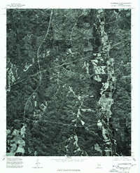 1975 Plantersville SW1977 Print · USGSCovers Valley Grande, including Jones, Valley Creek Junction, and other nearby areas
 - 1975 Map of Benton NW, 1977 Print
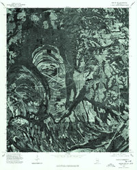 1975 Benton NW1977 Print · USGSDallas County during the mid-1970s is seen through a detailed aerial lens, capturing the rural landscape between the city and surrounding settlements. Researchers can trace the development of Selma and locate the smaller hubs of Burnsville and Brantley.
 - 1975 Map of Summerfield SE, 1977 Print
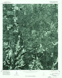 1975 Summerfield SE1977 Print · USGSDallas County is captured in mid-1970s aerial detail, documenting the rural landscape and timber tracts of the Alabama interior. Trace local land use and transit patterns along the corridor of State Route 219 as it appeared during the 1975 survey.
 - 1975 Map of Selma, 1977 Print
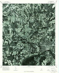 1975 Selma1977 Print · USGSSelma and the surrounding Dallas County countryside are captured in this mid-seventies aerial survey. Researchers can trace the riverfront development along the Alabama River and locate properties near Selma and the rural settlement of Potter.
End of results
Showing maps 1-4 of 4
Top cities near Valley Grande
Frequently asked questions
- What are the different types of historical maps available for Valley Grande?
- What is the oldest map of Valley Grande?
- Where can I purchase historical maps of Valley Grande for my home or office?
- Where can I download high-res historical maps of Valley Grande?
- Are there historical topographic maps available for Valley Grande?
- Is there historical aerial imagery available for Valley Grande?
- Where are historical maps of Valley Grande sourced from?