1980s Maps of Valley Grande, Alabama
Explore 8 historic maps of Valley Grande from the 1980s. These maps offer a rare glimpse into what life looked like during the 1980s — showing old roads, neighborhoods, homes, and landmarks that have changed or disappeared over time.
Whether you're researching your family's past, planning a metal detecting trip, or studying how Valley Grande's landscape evolved across the 1980s, these high-resolution maps are a powerful tool for exploring the history of this region.
- Focus on a specific era: All maps on this page are from the 1980s, giving you a focused view of this time period.
- See what’s changed: Compare century-old streets, trails, and buildings to today's modern landscape using overlays and satellite layers.
- Research with precision: Use these maps for genealogy, historical research, land use analysis, or educational projects.
- View, download, or print: Maps are fully viewable online in high resolution, and can be downloaded or printed for your own records.
Start exploring Valley Grande's history through authentic maps from the 1980s. This is your window into the past.
Valley Grande, AL maps
(8)- 1982 Map of Burnsville, 1983 Print
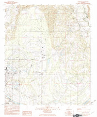 1982 Burnsville1983 Print · USGSIn the early 1980s, the area around the Dallas and Autauga county line remained a landscape of riverfront commerce and rural outposts. Local history researchers can trace the outskirts of Selma and Selmont or locate smaller settlements like Burnsville and Manila near the Blue Gurth Swamp.
 - 1982 Map of Jones, 1983 Print
 1982 Jones1983 Print · USGSThe borderlands of Dallas and Autauga counties are captured here in the early eighties, centered on the SOUTHERN rail line and Mulberry Creek. Researchers can trace rural lineages through numerous landmarks like Pea Ridge Cem, Cedar Grove Ch, and the settlement at Vine Hill.
 - 1986 Map of Montgomery
 1986 Montgomery1986 Print · USGSCentral Alabama's river-and-rail corridor is captured in the mid-1980s, centered on the state capital and its surrounding rural counties. Researchers can trace ancestral landmarks like Oakwood Cemetery, military sites like Maxwell Air Force Base, and small towns such as Lowndesboro.2 unique versions available
 - 1986 Map of Clanton
 1986 Clanton1986 Print · USGSCentral Alabama’s river-driven landscape is captured here in the mid-eighties, centered on the growth of Clanton and the hydroelectric lakes of the Coosa River. Genealogists and historians can trace the Old Indian Treaty Boundary or locate landmarks like Sykes Mill and Collins Chapel.
 - 1986 Map of Selma
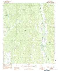
 1986 Selma1986 Print · USGSCentral Alabama's river and rail networks are preserved here in the mid-eighties, showing the transition from river travel to modern infrastructure. Researchers can trace the layout of Selma, the historic capital at Cahaba, and the Millers Ferry Lock and Dam.2 unique versions available
 - 1986 Map of Demopolis
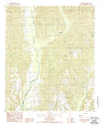
 1986 Demopolis1986 Print · USGSWest-central Alabama's river-and-rail corridors are preserved here in the mid-eighties, showing the deep-seated settlement patterns of the Black Belt. Genealogists and historians can locate family-named landmarks like Crenshaw Quarters or industrial sites including Cleveland Mills and the Warrior Lock and Dam.
 - 1987 Map of Summerfield
 1987 Summerfield1987 Print · USGSCentral Alabama in the late eighties reveals a landscape of dense woodlands and winding waterways along the Perry and Dallas County line. Researchers can trace the rural layouts of Perryville and Stonewall or locate the boundaries of Paul M Grist State Park.
 - 1987 Map of Clanton, 1990 Print
 1987 Clanton1990 Print · USGSCentral Alabama in the late eighties reveals a landscape of massive river reservoirs and forest reserves. Trace the rail-and-road corridors through Clanton and Wetumpka to find historic sites like Fort Toulouse and Collins Chapel.
End of results
Showing maps 1-8 of 8
Top cities near Valley Grande
Frequently asked questions
- What are the different types of historical maps available for Valley Grande?
- What is the oldest map of Valley Grande?
- Where can I purchase historical maps of Valley Grande for my home or office?
- Where can I download high-res historical maps of Valley Grande?
- Are there historical topographic maps available for Valley Grande?
- Is there historical aerial imagery available for Valley Grande?
- Where are historical maps of Valley Grande sourced from?