1980s Maps of Franklin County, Alabama
Explore 6 historic maps of Franklin County from the 1980s. These maps offer a rare glimpse into what life looked like during the 1980s — showing old roads, neighborhoods, homes, and landmarks that have changed or disappeared over time.
Whether you're researching your family's past, planning a metal detecting trip, or studying how Franklin County's landscape evolved across the 1980s, these high-resolution maps are a powerful tool for exploring the history of this region.
- Focus on a specific era: All maps on this page are from the 1980s, giving you a focused view of this time period.
- See what’s changed: Compare century-old streets, trails, and buildings to today's modern landscape using overlays and satellite layers.
- Research with precision: Use these maps for genealogy, historical research, land use analysis, or educational projects.
- View, download, or print: Maps are fully viewable online in high resolution, and can be downloaded or printed for your own records.
Start exploring Franklin County's history through authentic maps from the 1980s. This is your window into the past.
Franklin County, AL maps
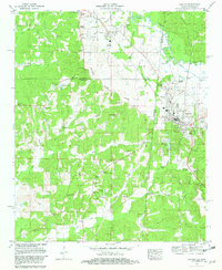
(6)- 1980 Map of Haleyville, 1983 Print
 1980 Haleyville1983 Print · USGSNorthwest Alabama at the start of the eighties shows a landscape of deep forests and new reservoirs as modern infrastructure settled into the hills. Researchers can trace the rail lines of the Southern and Illinois Central Gulf through towns like Haleyville, Moulton, and Natural Bridge.
 - 1981 Map of Red Bay, 1982 Print
 1981 Red Bay1982 Print · USGSThe Alabama-Mississippi borderlands come alive in the early eighties, centered on the growing town of Red Bay and the village of Belmont. Genealogists and local historians can trace family roots through numerous sites like New Carmel Church, Hodge Cem, and the Banner Community Center.
 - 1984 Map of Corinth
 1984 Corinth1984 Print · USGSNortheast Mississippi and its borders with Alabama and Tennessee are captured here in the mid-1980s, showcasing a landscape of rail-connected towns and ridge-top settlements. Researchers can trace the path of the Natchez Trace Parkway or locate family-named landmarks near Biggersville, Kossuth, and the historic Tennessee Divide.
 - 1984 Map of Tupelo
 1984 Tupelo1984 Print · USGSNorth Mississippi in the 1980s is defined by its massive river basin reservoirs and the growing regional hubs of Tupelo and Oxford. Researchers can trace the legacy of the Pontotoc Ridge, find the University of Mississippi, and map early Interstate corridors near Sardis Lake.3 unique versions available
 - 1984 Map of Tupelo, 1985 Print
 1984 Tupelo1985 Print · USGSNortheast Mississippi and the Alabama borderlands are shown in the mid-1980s as timber and river networks shaped the region. Trace local history through the Illinois Central Gulf rail line and sites like the Old Natchez Trace Parkway.
 - 1986 Map of Tuscumbia
 1986 Tuscumbia1986 Print · USGSThe Tennessee River valley in the mid-1980s shows a landscape transformed by massive reservoirs and industrial hubs. Genealogists and local historians can trace the development of the Shoals area and locate rural communities like Tharp Town, Leighton, and Rogersville.3 unique versions available
End of results
Showing maps 1-6 of 6
Top cities of Franklin County
- Russellville historical maps
- Red Bay historical maps
- Phil Campbell historical maps
- Vina historical maps
- Hodges historical maps
- Spruce Pine historical maps
Frequently asked questions
- What are the different types of historical maps available for Franklin County?
- What is the oldest map of Franklin County?
- Where can I purchase historical maps of Franklin County for my home or office?
- Where can I download high-res historical maps of Franklin County?
- Are there historical topographic maps available for Franklin County?
- Is there historical aerial imagery available for Franklin County?
- Where are historical maps of Franklin County sourced from?