1980s Maps of Mobile County, Alabama
Explore 26 historic maps of Mobile County from the 1980s. These maps offer a rare glimpse into what life looked like during the 1980s — showing old roads, neighborhoods, homes, and landmarks that have changed or disappeared over time.
Whether you're researching your family's past, planning a metal detecting trip, or studying how Mobile County's landscape evolved across the 1980s, these high-resolution maps are a powerful tool for exploring the history of this region.
- Focus on a specific era: All maps on this page are from the 1980s, giving you a focused view of this time period.
- See what’s changed: Compare century-old streets, trails, and buildings to today's modern landscape using overlays and satellite layers.
- Research with precision: Use these maps for genealogy, historical research, land use analysis, or educational projects.
- View, download, or print: Maps are fully viewable online in high resolution, and can be downloaded or printed for your own records.
Start exploring Mobile County's history through authentic maps from the 1980s. This is your window into the past.
Mobile County, AL maps
(26)- 1980 Map of The Basin, 1981 Print
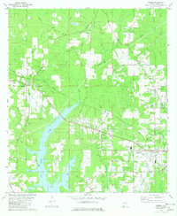
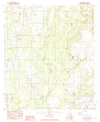
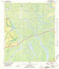 1980 The Basin1981 Print · USGSThe Mobile-Tensaw Delta is captured here during the 1980s, revealing a complex network of bayous and river bends. Local historians can locate the Fort Louis Historical Marker and trace the winding paths of Bayou Dead Lake and Bayou Fisher.3 unique versions available
 - 1981 Map of Bay Minette
 1981 Bay Minette1981 Print · USGSThe Alabama-Florida borderlands come to life in the early 1980s as the river delta meets the growing coastal communities. Researchers can trace the Louisville and Nashville rail lines or locate historical points like Twenty-two Mile Bluff and the Blackwater River State Forest.2 unique versions available
 - 1982 Map of Citronelle West
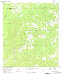 1982 Citronelle West1982 Print · USGSMobile County and Washington County meet at the Esca Tawpa River in the early eighties, where timberlands and oil exploration define the landscape. Genealogists can trace family landmarks like New Hope Cemetery, Bethel Church, and the Oil City Speedway.2 unique versions available
 - 1982 Map of Citronelle East
 1982 Citronelle East1982 Print · USGSMobile County settlements and petroleum production are captured here in the early eighties. Genealogists and historians can trace family sites like St Annes Cem and Meinhardt Cem alongside the ILLINOIS CENTRAL GULF railroad.2 unique versions available
 - 1982 Map of Calvert
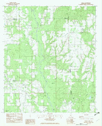
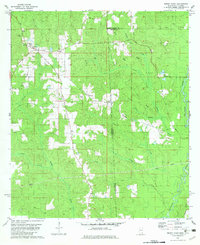
 1982 Calvert1982 Print · USGSSouthwestern Alabama's timber and rail country comes to life in the early 1980s. Genealogists and local historians can trace family locations near numerous rural landmarks like Vaughn Cem, Byrd Chapel, and the Fairford Lookout Tower.
 - 1982 Map of Hurley
 1982 Hurley1982 Print · USGSCrossing the Mississippi-Alabama border in the early eighties, this survey captures the rural landscape of Jackson and George Counties. You can trace family roots through Tanners Chapel, locate the Coleman Cem, and follow the winding Es Catawpa River past Red Bluff.2 unique versions available
 - 1982 Map of Creola
 1982 Creola1982 Print · USGSMobile County settlements are mapped in detail during the early eighties as the rail-and-creek landscape of Creola and Axis continued to develop. Genealogists can trace family locations near Forest Lawn Cem, Little Bethel Ch, and the outlying crossroads of Turnerville.3 unique versions available
 - 1982 Map of Earlville
 1982 Earlville1982 Print · USGSThe Alabama and Mississippi borderlands come into focus in the early eighties, showcasing a rural landscape defined by the winding Escatawpa River. Genealogists and local historians can trace family roots at Moffet Cem or visit community landmarks like Macedonia Ch and Earlville.3 unique versions available
 - 1982 Map of Deer Park
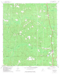
 1982 Deer Park1982 Print · USGSThe timber and rail corridor of Washington County is captured here in the early eighties. Researchers can trace the Illinois Central Gulf through Deer Park, locating family landmarks like Weldy Cem and New Light Ch.2 unique versions available
 - 1982 Map of Biloxi
 1982 Biloxi1982 Print · USGSThe Mississippi and Alabama coastlines are captured in the early eighties as industrial hubs and wildlife refuges shaped the shoreline. Trace maritime and military history through Fort Morgan, Keesler Air Force Base, and the barrier islands of Gulf Islands National Seashore.2 unique versions available
 - 1982 Map of Georgetown
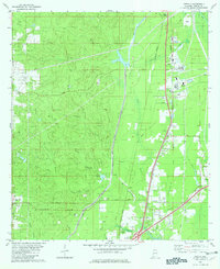
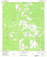 1982 Georgetown1982 Print · USGSGeorgetown and the surrounding Mobile County backcountry are captured in the early eighties as a landscape of rural family settlements and winding creek branches. Genealogists can trace local roots through Lott Cem and Boothetown, while exploring industrial landmarks like the Garrison Lookout Tower.3 unique versions available
 - 1982 Map of Mount Vernon
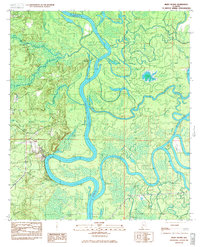
 1982 Mount Vernon1982 Print · USGSThe Mobile River riverfront and the town of Mt Vernon appear in the early eighties as a hub of rail activity and industrial transit. Researchers can trace the grounds of Searcy State Hospital or locate local landmarks like Stage Coach Woods and Chastang Landing.2 unique versions available
 - 1982 Map of Brown Town
 1982 Brown Town1982 Print · USGSThe Alabama and Mississippi borderlands are captured here in the early eighties, showcasing a rural landscape of timbered ridges and creek bottoms. Local researchers can locate Mt Pisgah Ch, the Maples Cem, and the small settlements of Brown Town and Pisgah.3 unique versions available
 - 1982 Map of Semmes
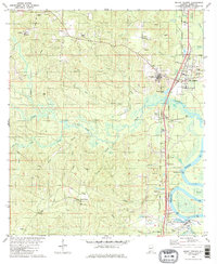
 1982 Semmes1982 Print · USGSCoastal Alabama's West Mobile region is shown here in the early 1980s, centered on the expansive waters of Big Creek Lake. Genealogists and local historians can trace family markers at Allentown Cem or Town Cem and locate schools like Montgomery High Sch.2 unique versions available
 - 1982 Map of Sims Chapel
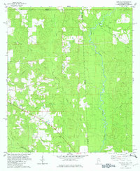
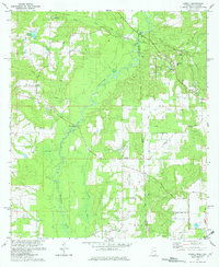
 1982 Sims Chapel1982 Print · USGSLower Washington and Mobile counties appear in the early eighties as a landscape of timber, rail, and emerging oil production. Genealogists and local historians can trace the communities of Sims Chapel and Charity Chapel, or locate family sites at Sawyer Cem and Red Wash Cem.
 - 1982 Map of Howell
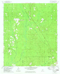
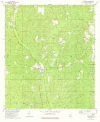
 1982 Howell1982 Print · USGSCrossing the state line between Mississippi and Alabama in the early eighties, this area shows a landscape defined by the Es Catawpa River and rural crossroads. Genealogists can locate family-named landmarks like Moffetville Ch, Ward Cem, and Howell Bridge.2 unique versions available
 - 1982 Map of Chunchula
 1982 Chunchula1982 Print · USGSCoastal Alabama's pine woods and creek bottoms are documented here in the early eighties, centered on the Chunchula community. Genealogists and historians can trace the Illinois Central Gulf rail line past Turnerville Ch, Starlight Ch, and several family-named waterways.2 unique versions available
 - 1982 Map of Big Point, 1983 Print
 1982 Big Point1983 Print · USGSCoastal plains and river bottomlands meet along the Mississippi-Alabama border in the early eighties, where the Escatawpa River carves through dense swamps. Researchers can locate community anchors like Temple Church and Forts Lake Cemetery or trace old river access points at Galloway Landing.2 unique versions available
 - 1982 Map of Petit Bois Island, 1983 Print
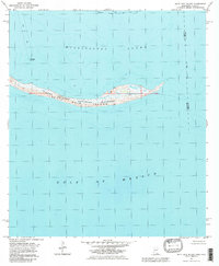 1982 Petit Bois Island1983 Print · USGSThe barrier island landscape of the Mississippi coast is captured here in the early eighties, showing the narrow stretch of Petit Bois Island. Maritime historians can trace the Horn Island Lighthouse and the state boundary line between Alabama and Mississippi.2 unique versions available
 - 1983 Map of Bilbo Island
 1983 Bilbo Island1983 Print · USGSThe confluence of the Alabama and Tombigbee Rivers is captured here in the early 1980s, marking the boundary of four coastal counties. Researchers can trace river landmarks and backwater features like Little Shanty Landing, Bilbo Lake, and the headwaters of the Mobile River.2 unique versions available
 - 1983 Map of Stiggings Lake
 1983 Stiggings Lake1983 Print · USGSThe river delta between Mobile and Baldwin counties is captured here in the early eighties, showcasing a labyrinth of wetlands and historic landings. Researchers can trace the sites of Ft Stoddard and an Indian Mound, or locate local landmarks like Belsaw Sch and Meathers Landing.2 unique versions available
 - 1984 Map of Citronelle
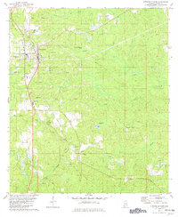
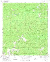
 1984 Citronelle1984 Print · USGSThe Alabama-Mississippi borderlands in the mid-1980s were a hub of timber and rail, spanning from the Leaf River to the Mobile County line. Genealogists can trace family roots through rural communities like Sims Chapel, Leakesville, and Vinegar Bend.2 unique versions available
 - 1984 Map of Hattiesburg
 1984 Hattiesburg1984 Print · USGSSouth Mississippi’s Pine Belt is seen here in the mid-eighties, showing the region as a hub of timber production and petroleum extraction. Trace the rail lines of the Illinois Central Gulf RR through old settlements like Richton or the energy developments at the Heidelberg Oil Field.2 unique versions available
 - 1984 Map of Mobile
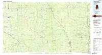
 1984 Mobile1984 Print · USGSMobile and its surrounding Gulf Coast backcountry appear in the mid-eighties as a hub of maritime industry and timber management. Genealogists and historians can trace the development of the riverfront near McDuffie Island or explore rural settlements like Lucedale and Chunchula.
 - 1984 Map of Mobile
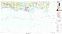
 1984 Mobile1984 Print · USGSThe Gulf Coast at the height of the mid-eighties shows a landscape of rapid industrial growth and military significance. Researchers can trace the sprawling rail lines of the Illinois Central Gulf RR, locate the NASA Test Facility, or study the barrier island chain from Cat Island to Petit Bois Island.3 unique versions available
Showing maps 1-25 of 26
Top cities of Mobile County
- Mobile historical maps
- Prichard historical maps
- Tillmans Corner historical maps
- Saraland historical maps
- Satsuma historical maps
- Chickasaw historical maps
See more
Frequently asked questions
- What are the different types of historical maps available for Mobile County?
- What is the oldest map of Mobile County?
- Where can I purchase historical maps of Mobile County for my home or office?
- Where can I download high-res historical maps of Mobile County?
- Are there historical topographic maps available for Mobile County?
- Is there historical aerial imagery available for Mobile County?
- Where are historical maps of Mobile County sourced from?