1950s Maps of Mobile County, Alabama
Explore 32 historic maps of Mobile County from the 1950s. These maps offer a rare glimpse into what life looked like during the 1950s — showing old roads, neighborhoods, homes, and landmarks that have changed or disappeared over time.
Whether you're researching your family's past, planning a metal detecting trip, or studying how Mobile County's landscape evolved across the 1950s, these high-resolution maps are a powerful tool for exploring the history of this region.
- Focus on a specific era: All maps on this page are from the 1950s, giving you a focused view of this time period.
- See what’s changed: Compare century-old streets, trails, and buildings to today's modern landscape using overlays and satellite layers.
- Research with precision: Use these maps for genealogy, historical research, land use analysis, or educational projects.
- View, download, or print: Maps are fully viewable online in high resolution, and can be downloaded or printed for your own records.
Start exploring Mobile County's history through authentic maps from the 1950s. This is your window into the past.
Mobile County, AL maps
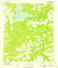
(32)- 1953 Map of Hurricane, 1954 Print
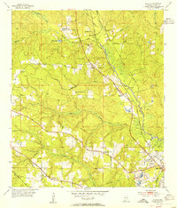
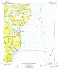
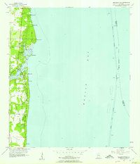
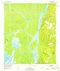 1953 Hurricane1954 Print · USGSThe Alabama delta and its bluff-side settlements are captured here in the early 1950s, showing a landscape defined by its waterways and railroads. Genealogists and historians can locate CIVIL WAR TRENCHES, the historic Blakeley Sch, and numerous family burial grounds like Wilkins Cem.6 unique versions available
 - 1953 Map of Spring Hill, 1954 Print
 1953 Spring Hill1954 Print · USGSThe suburbs of western Mobile are shown in detail during the early fifties as the city expanded past its traditional limits. Researchers can trace local development through landmarks like Spring Hill College, Bates Field, and the Mobile Country Club.6 unique versions available
 - 1953 Map of Daphne, 1954 Print
 1953 Daphne1954 Print · USGSThe Eastern Shore of Mobile Bay is captured in the early fifties, showing the growth of coastal communities from Daphne to Fairhope. Genealogists and historians can locate family homes and community landmarks like the Baldwin Co Training Sch, Jackson Oak, and Tatumville.5 unique versions available
 - 1953 Map of Bridgehead, 1954 Print
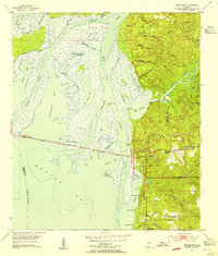 1953 Bridgehead1954 Print · USGSThe eastern shore of Mobile Bay appears in the early fifties as a landscape of tidal marshes and strategic bluffs. Genealogists and historians can locate Civil War Trenches near Fort McDermott and trace family roots at Blakeley Cem or D'Olive Cem.6 unique versions available
 - 1953 Map of Kushla, 1954 Print
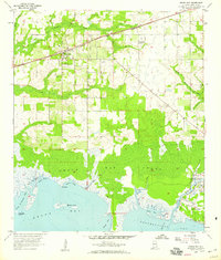
 1953 Kushla1954 Print · USGSThe rural outskirts of Mobile are documented in the early fifties as the region's railroad and river networks shaped local life. Genealogists and historians can trace family-named landmarks and centers of worship like St Johns Chapel, Mauvilla Cem, and Mt Pilgrim Ch.6 unique versions available
 - 1953 Map of Chickasaw, 1955 Print
 1953 Chickasaw1955 Print · USGSCoastal Alabama's industrial and residential growth comes into focus in this mid-century survey of the Mobile riverfront. Genealogists and historians can trace the foundations of Chickasaw and Saraland, identifying family landmarks like Saraland Cem, Myers Cem, and the old Ship Yard.6 unique versions available
 - 1953 Map of Theodore, 1955 Print
 1953 Theodore1955 Print · USGSIn the early 1950s, Mobile County’s coastal interior was a landscape of rail-side towns and winding rivers just before the suburban expansion of Mobile reached its peak. Researchers can trace historic family landmarks including the County Farm, Magnolia Church, and the winding Old Spanish Trail.6 unique versions available
 - 1953 Map of Mobile, 1955 Print
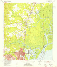
 1953 Mobile1955 Print · USGSMobile and its neighboring industrial suburbs thrive in the mid-1950s as the riverfront reaches its peak as a rail and maritime gateway. Researchers can locate specific family homesites near Barton Academy, the sprawling Brookley Air Force Base, or the grounds of Magnolia Cemetery.5 unique versions available
 - 1953 Map of Hollingers Island, 1955 Print
 1953 Hollingers Island1955 Print · USGSMobile Bay's western shore in the early fifties shows a blend of military activity and coastal leisure. Researchers can trace the development of South Brookley and Hollingers Island, locating landmarks like the Alba Club, Casher Cem, and New Hope Ch.5 unique versions available
 - 1953 Map of Andalusia, 1965 Print
 1953 Andalusia1965 Print · USGSSouth Alabama in the mid-twentieth century remains a land of pine forests and river-fed settlements. You can trace the vital rail corridors of the Louisville & Nashville and locate regional centers such as Andalusia, Brewton, and Monroeville.3 unique versions available
 - 1953 Map of Hattiesburg, 1965 Print
 1953 Hattiesburg1965 Print · USGSSouth Mississippi and western Alabama are shown here during the mid-twentieth century as the timber and rail industries shaped the region. Genealogists and historians can trace rail lines like the Mississippi Central and locate rural centers such as Magee, Richton, and Mount Vernon.4 unique versions available
 - 1953 Map of Mobile, 1968 Print
 1953 Mobile1968 Print · USGSThe Gulf Coast comes alive in this mid-century survey, from the streets of Mobile to the marshes of New Orleans. Trace family roots in coastal towns like Pass Christian and Bayou La Batre or locate military landmarks including Keesler AFB.3 unique versions available
 - 1956 Map of Bellefontaine, 1957 Print
 1956 Bellefontaine1957 Print · USGSThe Alabama coastline along Mobile Bay in the mid-1950s reveals a world of tidal bayous and small shorefront settlements. Researchers can trace the Old Railroad Grade south toward Pt Judith or locate family sites near Boudans Cem and Bayleys Corner.4 unique versions available
 - 1956 Map of Coden, 1957 Print
 1956 Coden1957 Print · USGSThe Alabama coast in the mid-1950s is captured here, from the bustling waterfront of Bayou La Batre to the famous Bellingrath Gardens. Researchers can trace old family sites and transport routes through Coden, St Pauls Ch, and an Old Railroad Grade.3 unique versions available
 - 1957 Map of Mobile
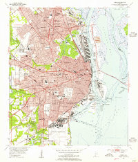
 1957 Mobile1957 Print · USGSThe Gulf Coast in the mid-1950s reveals a bustling corridor of rail-and-river commerce connecting Alabama to Louisiana. Genealogists and historians can trace old settlements and military hubs from Keesler Afb to the coastal reaches of Ship Island and Bogalusa.3 unique versions available
 - 1957 Map of Andalusia
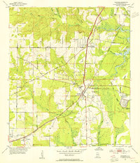
 1957 Andalusia1957 Print · USGSSouthern Alabama in the mid-1950s was a landscape defined by timbered stretches and the rhythmic flow of the Alabama River. Researchers can trace the legacy of the rail era through the Central of Georgia tracks and the storied river bluffs at Choctaw Bluff.
 - 1957 Map of St. Elmo, 1958 Print
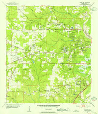
 1957 St. Elmo1958 Print · USGSMobile County’s coastal plain comes into focus in the mid-fifties, showing a rural landscape organized around the L & N RR and winding creek branches. Researchers can locate historic community hubs like Dawes-Union Sch, St Johns Ch, and the St Elmo Landing Field.4 unique versions available
 - 1957 Map of Tanner Williams, 1958 Print
 1957 Tanner Williams1958 Print · USGSWestern Mobile County in the late fifties shows a rural landscape transitioning around the new Big Creek Lake. Genealogists and local historians can locate several family cemeteries and country churches, including Tanner Williams, Seven Hills, and Dees Cem.5 unique versions available
 - 1957 Map of Pensacola, 1967 Print
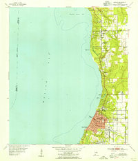
 1957 Pensacola1967 Print · USGSThe Florida Panhandle and Alabama coast are seen here at the height of the Cold War, showcasing a unique mix of military aviation and emerging beach tourism. Genealogists and local historians can trace legacy sites like Old Corry Field, the lumber town of Bagdad, and the coastal reaches of Santa Rosa Island.3 unique versions available
 - 1958 Map of Little Dauphin Island
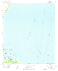 1958 Little Dauphin Island1958 Print · USGSMobile Bay and the Alabama coastline are captured here in the late fifties, showing the vital maritime corridors of the Gulf. Researchers can trace the early road network on Dauphin Island and locate heritage sites like Indian Mound Park or Alabama Port.3 unique versions available
 - 1958 Map of Hattiesburg
 1958 Hattiesburg1958 Print · USGSSoutheastern Mississippi's timber and rail networks are at their peak during the late fifties, centered on the growing hubs of Hattiesburg and Laurel. Researchers can trace old family landmarks like Sims Chapel, the Busbey Game Refuge, and the vanished stops along the Mississippi Central railroad.2 unique versions available
 - 1958 Map of Fort Morgan, 1959 Print
 1958 Fort Morgan1959 Print · USGSThe entrance to Mobile Bay in the late fifties was defined by its coastal defenses and shifting maritime channels. History buffs can trace the layouts of Fort Morgan and Fort Gaines or locate landmarks like the Sand Island Lighthouse and Bienville Beach.4 unique versions available
 - 1958 Map of Heron Bay, 1959 Print
 1958 Heron Bay1959 Print · USGSCoastal Alabama at the end of the fifties reveals a complex network of bayous and sounds before extensive modern development. Trace the early shoreline of Dauphin Island and find historic water crossings at Grants Pass and Cedar Point.3 unique versions available
 - 1958 Map of Grand Bay, 1959 Print
 1958 Grand Bay1959 Print · USGSCoastal Mobile County is shown here in the late fifties, where the railroad and the Gulf shoreline shaped local life. Genealogists and historians can trace the inland settlement of Grand Bay, the St Elmo Landing Field, and the fishing waters of Bayou La Batre.3 unique versions available
 - 1958 Map of Fort Morgan NW, 1959 Print
 1958 Fort Morgan NW1959 Print · USGSDauphin Island during the late fifties reveals an emerging coastal settlement and its primary thoroughfare, Bienville Blvd. Researchers can trace early residential expansion and compare historical shorelines along the Mississippi Sound.2 unique versions available
Showing maps 1-25 of 32
Top cities of Mobile County
- Mobile historical maps
- Prichard historical maps
- Tillmans Corner historical maps
- Saraland historical maps
- Satsuma historical maps
- Chickasaw historical maps
See more
Frequently asked questions
- What are the different types of historical maps available for Mobile County?
- What is the oldest map of Mobile County?
- Where can I purchase historical maps of Mobile County for my home or office?
- Where can I download high-res historical maps of Mobile County?
- Are there historical topographic maps available for Mobile County?
- Is there historical aerial imagery available for Mobile County?
- Where are historical maps of Mobile County sourced from?