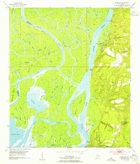
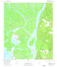
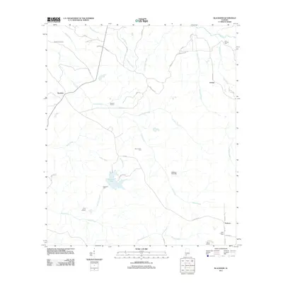
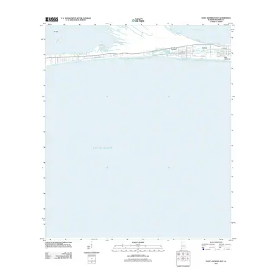
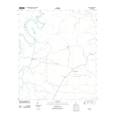
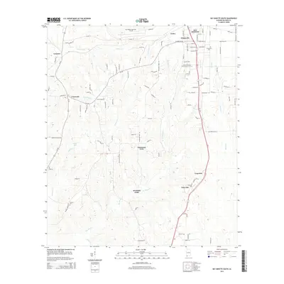
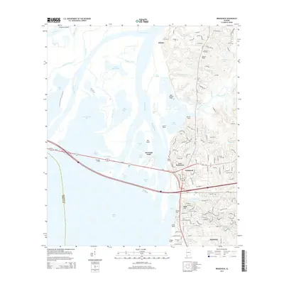
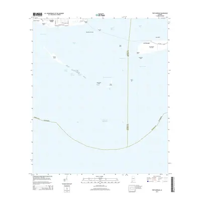
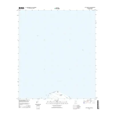
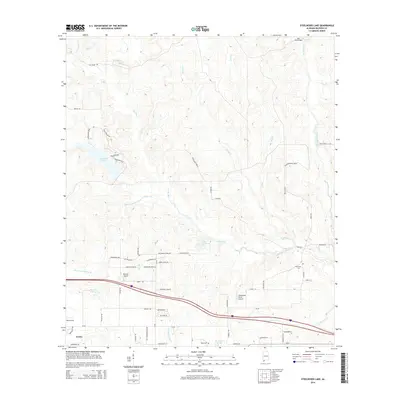
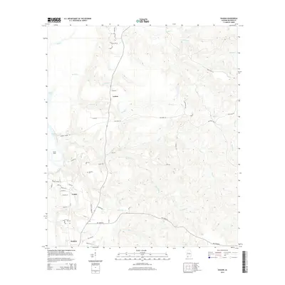
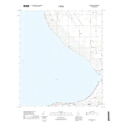
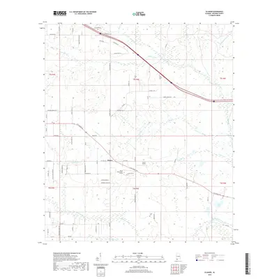
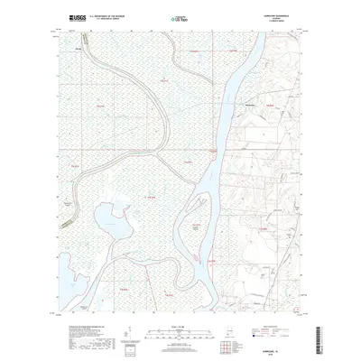
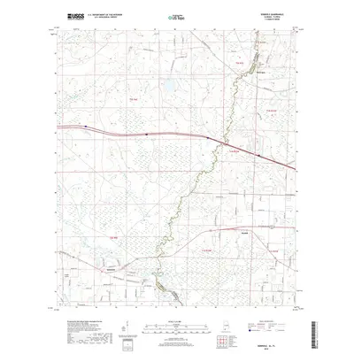
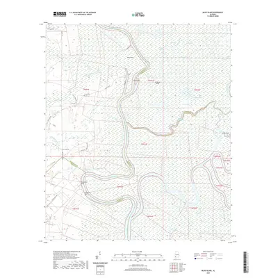
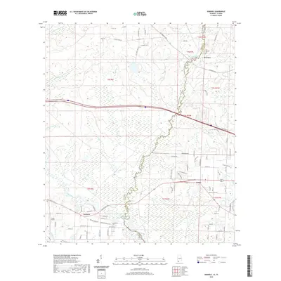
1953 Map of Hurricane
USGS Topo · Published 1954About this map
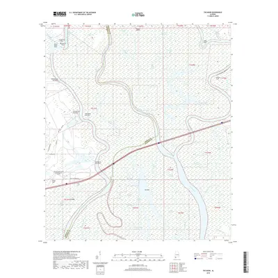
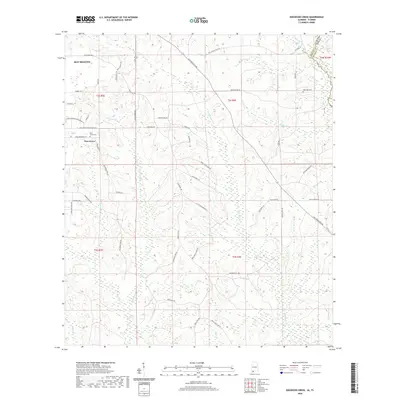
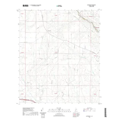
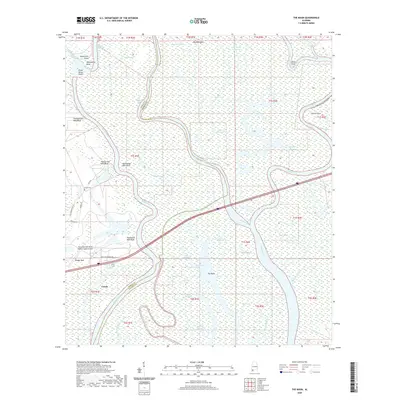
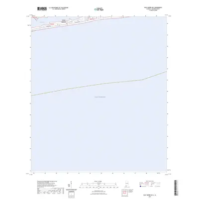
Civil War Trenches line the bluffs overlooking the Mobile River delta, marking a landscape where military history and a complex riverine economy intersect. The terrain transitions sharply from the deep, swampy lowlands of Chuckfee Bay and Gravine Island to the elevated ground of Stony Hill. This 1953 revision documents a network of landings such as Perkins Landing and Sizemore Landing that served the local timber and river trade. Inland, the Louisville and Nashville railroad passes through Ortiz Siding, providing a vital transit link parallel to the delta. Local life is anchored by community landmarks like St Johns Ch, Magnolia Ch, and the Blakeley Sch, while several family burial grounds, including Miller Cem and Wilkins Cem, offer significant genealogical data for researchers. The map also captures the intricate maze of bayous, such as Big Bayou Canot and Alligator Bayou, which defined the delta's navigation and drainage patterns before modern alterations.
Find a feature on this map
60 named features on this map. Tap any name to fly to it.
Don’t see what you’re looking for? This feature index may not catch every label — zoom into the map to look around manually.
Map Details
Editions of this 1953 Hurricane Map
6 editions found
Historical Maps of Mobile Through Time
154 maps found

1941 Blakeley
Baldwin County, AL

1941 Weeks Bay
Baldwin County, AL

1942 Blakeley
Baldwin County, AL

1942 Dyas
Baldwin County, AL

1942 Hurricane
Baldwin County, AL

1943 Blakeley
Baldwin County, AL

1943 Hurricane
Baldwin County, AL

1943 Tensaw
Baldwin County, AL

1943 Weeks Bay
Baldwin County, AL

1944 Dyas
Baldwin County, AL

1944 Miflin
Baldwin County, AL

1944 Muscogee
Baldwin County, AL

1944 Tensaw
Baldwin County, AL

1953 Bridgehead
Baldwin County, AL

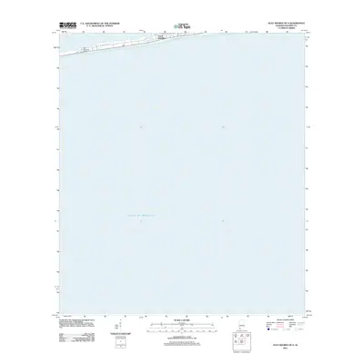
1953 Hurricane
Baldwin County, AL

1958 Fort Morgan
Baldwin County, AL

1978 Dogwood Creek
Baldwin County, AL

1978 Dyas
Baldwin County, AL

1978 Gateswood
Baldwin County, AL

1978 Seminole
Baldwin County, AL

1980 Bay Minette North
Baldwin County, AL

1980 Bay Minette South
Baldwin County, AL

1980 Bon Secour Bay
Baldwin County, AL

1980 Elsanor
Baldwin County, AL

1980 Little Point Clear
Baldwin County, AL

1980 Pine Beach
Baldwin County, AL

1980 St. Andrews Bay
Baldwin County, AL

1980 Steelwood Lake
Baldwin County, AL

1980 The Basin
Baldwin County, AL

1983 Bilbo Island
Baldwin County, AL

1983 Blacksher
Baldwin County, AL

1983 Stiggings Lake
Baldwin County, AL

1983 Tensaw
Baldwin County, AL

1983 Vaughn
Baldwin County, AL

1986 Bay Minette North
Baldwin County, AL

1994 Dogwood Creek
Baldwin County, AL

1994 Dyas
Baldwin County, AL

1994 Gateswood
Baldwin County, AL

1997 Hurricane
Baldwin County, AL

2003 Dyas
Baldwin County, AL
2011 Bay Minette North
Baldwin County, AL
2011 Bay Minette South
Baldwin County, AL
2011 Bilbo Island
Baldwin County, AL
2011 Blacksher
Baldwin County, AL
2011 Bon Secour Bay
Baldwin County, AL
2011 Bridgehead
Baldwin County, AL
2011 Dogwood Creek
Baldwin County, AL
2011 Dyas
Baldwin County, AL
2011 Elsanor
Baldwin County, AL
2011 Fort Morgan
Baldwin County, AL
2011 Gateswood
Baldwin County, AL
2011 Gulf Shores OE S
Baldwin County, AL
2011 Hurricane
Baldwin County, AL
2011 Little Point Clear
Baldwin County, AL
2011 Pine Beach
Baldwin County, AL
2011 Saint Andrews Bay
Baldwin County, AL
2011 Seminole
Baldwin County, AL
2011 Steelwood Lake
Baldwin County, AL
2011 Stiggins Lake
Baldwin County, AL
2011 Tensaw
Baldwin County, AL
2011 The Basin
Baldwin County, AL
2011 Vaughn
Baldwin County, AL
2014 Bay Minette North
Baldwin County, AL
2014 Bay Minette South
Baldwin County, AL
2014 Bilbo Island
Baldwin County, AL
2014 Blacksher
Baldwin County, AL
2014 Bon Secour Bay
Baldwin County, AL
2014 Bridgehead
Baldwin County, AL
2014 Dogwood Creek
Baldwin County, AL
2014 Dyas
Baldwin County, AL
2014 Elsanor
Baldwin County, AL
2014 Fort Morgan
Baldwin County, AL
2014 Gateswood
Baldwin County, AL
2014 Gulf Shores OE S
Baldwin County, AL
2014 Hurricane
Baldwin County, AL
2014 Little Point Clear
Baldwin County, AL
2014 Pine Beach
Baldwin County, AL
2014 Saint Andrews Bay
Baldwin County, AL
2014 Seminole
Baldwin County, AL
2014 Steelwood Lake
Baldwin County, AL
2014 Stiggins Lake
Baldwin County, AL
2014 Tensaw
Baldwin County, AL
2014 The Basin
Baldwin County, AL
2014 Vaughn
Baldwin County, AL
2018 Bay Minette North
Baldwin County, AL

2018 Bay Minette South
Baldwin County, AL
2018 Bilbo Island
Baldwin County, AL
2018 Blacksher
Baldwin County, AL
2018 Bon Secour Bay
Baldwin County, AL
2018 Bridgehead
Baldwin County, AL
2018 Dogwood Creek
Baldwin County, AL
2018 Dyas
Baldwin County, AL
2018 Elsanor
Baldwin County, AL
2018 Fort Morgan
Baldwin County, AL
2018 Gateswood
Baldwin County, AL
2018 Gulf Shores OE S
Baldwin County, AL
2018 Hurricane
Baldwin County, AL
2018 Little Point Clear
Baldwin County, AL
2018 Pine Beach
Baldwin County, AL
2018 Saint Andrews Bay
Baldwin County, AL
2018 Seminole
Baldwin County, AL
2018 Steelwood Lake
Baldwin County, AL
2018 Stiggins Lake
Baldwin County, AL
2018 Tensaw
Baldwin County, AL
2018 The Basin
Baldwin County, AL
2018 Vaughn
Baldwin County, AL
2020 Bay Minette North
Baldwin County, AL
2020 Bay Minette South
Baldwin County, AL
2020 Bilbo Island
Baldwin County, AL
2020 Blacksher
Baldwin County, AL
2020 Bon Secour Bay
Baldwin County, AL
2020 Bridgehead
Baldwin County, AL
2020 Dogwood Creek
Baldwin County, AL
2020 Dyas
Baldwin County, AL
2020 Elsanor
Baldwin County, AL
2020 Fort Morgan
Baldwin County, AL
2020 Gateswood
Baldwin County, AL

2020 Hurricane
Baldwin County, AL
2020 Little Point Clear
Baldwin County, AL
2020 Pine Beach
Baldwin County, AL
2020 Saint Andrews Bay
Baldwin County, AL
2020 Seminole
Baldwin County, AL
2020 Steelwood Lake
Baldwin County, AL
2020 Stiggins Lake
Baldwin County, AL
2020 Tensaw
Baldwin County, AL
2020 The Basin
Baldwin County, AL
2020 Vaughn
Baldwin County, AL
2021 Gulf Shores OE S
Baldwin County, AL

2024 Bay Minette North
Baldwin County, AL

2024 Bay Minette South
Baldwin County, AL

2024 Bilbo Island
Baldwin County, AL

2024 Blacksher
Baldwin County, AL

2024 Bon Secour Bay
Baldwin County, AL

2024 Bridgehead
Baldwin County, AL

2024 Dogwood Creek
Baldwin County, AL

2024 Dyas
Baldwin County, AL

2024 Elsanor
Baldwin County, AL
2024 Fort Morgan
Baldwin County, AL

2024 Gateswood
Baldwin County, AL
2024 Gulf Shores OE S
Baldwin County, AL

2024 Hurricane
Baldwin County, AL

2024 Little Point Clear
Baldwin County, AL
2024 Pine Beach
Baldwin County, AL
2024 Saint Andrews Bay
Baldwin County, AL

2024 Seminole
Baldwin County, AL

2024 Steelwood Lake
Baldwin County, AL

2024 Stiggins Lake
Baldwin County, AL

2024 Tensaw
Baldwin County, AL

2024 The Basin
Baldwin County, AL

2024 Vaughn
Baldwin County, AL

2025 Fort Morgan
Baldwin County, AL

2025 Gulf Shores OE S
Baldwin County, AL

2025 Pine Beach
Baldwin County, AL

2025 Saint Andrews Bay
Baldwin County, AL