1940s Maps of Phenix City, Alabama
Explore 3 historic maps of Phenix City from the 1940s. These maps offer a rare glimpse into what life looked like during the 1940s — showing old roads, neighborhoods, homes, and landmarks that have changed or disappeared over time.
Whether you're researching your family's past, planning a metal detecting trip, or studying how Phenix City's landscape evolved across the 1940s, these high-resolution maps are a powerful tool for exploring the history of this region.
- Focus on a specific era: All maps on this page are from the 1940s, giving you a focused view of this time period.
- See what’s changed: Compare century-old streets, trails, and buildings to today's modern landscape using overlays and satellite layers.
- Research with precision: Use these maps for genealogy, historical research, land use analysis, or educational projects.
- View, download, or print: Maps are fully viewable online in high resolution, and can be downloaded or printed for your own records.
Start exploring Phenix City's history through authentic maps from the 1940s. This is your window into the past.
Phenix City, AL maps
(3)- 1947 Map of Columbus, 1954 Print
 1947 Columbus1954 Print · USGSPostwar Georgia and Alabama meet along the Chattahoochee River in this detailed study of military expansion and urban growth. Genealogists and historians can trace family-named landmarks across Fort Benning and locate sites like Riverdale Cem, Midway Ch, and Baker Village.2 unique versions available
 - 1949 Map of Fort Mitchell
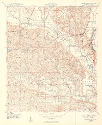 1949 Fort Mitchell1949 Print · USGSRussell County, Alabama, was a landscape of military expansion and rural rail stops shortly after the war. You can trace the Central of Georgia line as it passes through Fort Mitchell and Lato, or locate riverfront sites like Bradley Landing.2 unique versions available
 - 1949 Map of Columbus
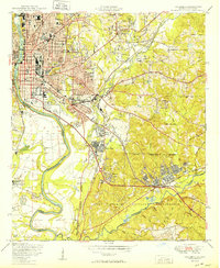 1949 Columbus1949 Print · USGSColumbus and Phenix City flank the Chattahoochee River during a period of massive military growth following the war. Genealogists can trace family footprints through Linwood Cem and neighborhood schools like St Elmo School or Jordan High School.2 unique versions available
End of results
Showing maps 1-3 of 3
Top cities near Phenix City
Top neighborhoods of Phenix City
- Greenbrier historical maps
- Garrett Heights historical maps
- Lakewood Heights historical maps
- Carriage Hill historical maps
- Rolling Hills historical maps
- Fontaine Village historical maps
See more
Frequently asked questions
- What are the different types of historical maps available for Phenix City?
- What is the oldest map of Phenix City?
- Where can I purchase historical maps of Phenix City for my home or office?
- Where can I download high-res historical maps of Phenix City?
- Are there historical topographic maps available for Phenix City?
- Is there historical aerial imagery available for Phenix City?
- Where are historical maps of Phenix City sourced from?